The Architectural History of the Kowloon Walled City
Situated northeast of the Kowloon Peninsula and five miles north of Hong Kong Island, the Kowloon Walled City has been a cohesive, named entity since at least the early 19th century.1 A fort was built on the site in 1810, and upon the suggestion of Qiying, the governor-general of Guangdong and Guangxi, an outer wall mounted with cannons was added in 1847, turning the area into an imperial Chinese zhaicheng (寨城 walled city) (Krone 1859: 105).
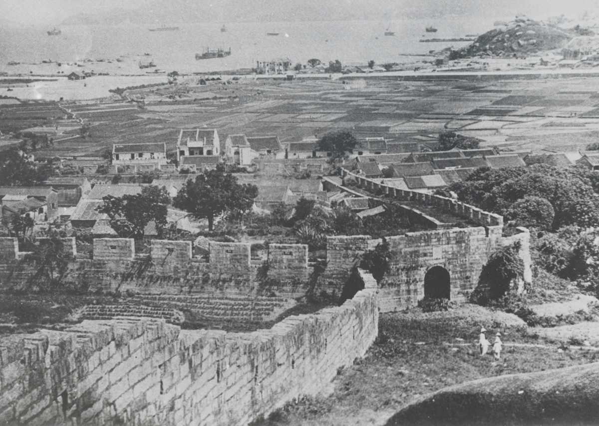
The Walled City was most densely inhabited from the 1960s to its demolition in 1994.2 During this time, it was a case study in vernacular building and an enclave of slum tenancy. Crime and hazardous construction practices ran rampant, and its six-acre space became crowded with improvised, multi-story dwellings joined by dimly lit alleyways. Architects and architectural historians began paying attention to the Walled City in the years immediately prior to and following its 1994 demolition. In particular, monographs produced between 1993 and 1999 documented comprehensive architectural studies of the Walled City (Ho 1993; Terasawa and Kani 1997; Lambot, Girard, and Wilkinson 1999). Meanwhile, the work of photographers such as Miyamoto Ryuji have cast the Walled City as a manifestation of — and sometime antithesis to — the planned, postwar East Asian urbanism of cities like Tokyo (Figure 1) (Cushman 2018).
However, the architectural history of the area predated its late-20th-century state. Since its days as a Qing Dynasty military outpost, the Walled City has sustained various additions and renovations, especially to the outer wall that gave shape to its boundaries. In other words, the Walled City’s earlier history was punctuated by land-use planning, in sharp contrast to its final iteration as an under-planned slum. What specters of these developments remained detectable within its later history?
This article is bookended by two events: first, the largest and last extension of Hong Kong’s colonial boundaries, as stipulated in the Convention Between the United Kingdom and China, otherwise known as the Convention of 1898, and second, the dissolution of Qing China in 1912. I identify two systems of land management as major turning points that shaped the area’s turn-of-the-century architectural history: Qing land deeds, a Ming Dynasty legacy still in place under the Qing, and the colonial British cadastral system, established after comprehensive land surveys. With its focus on the Walled City’s late-20th-century history, existing architectural scholarship rarely considers the circumvention of one system by the other. That interplay is precisely my article’s focus. Rather than seeing the clash between these systems as an obstacle to understanding, I use it to illuminate how the Walled City became systematically obscured between 1898 and 1912. I apply Bruno Latour’s concept of maps as ‘immutable mobiles’ (1986) to explain the supplantation of Qing land deeds by map-based British cadastral surveys, treating this 14-year period as a time of rapid change in both epistemological and spatial realms. Furthermore, by focusing on two architectural anchors, the Walled City’s administrative yamen (衙門) office and its outer wall, I call into question the power and, indeed, the true immutability of maps. This history of overlapping systems most significantly resulted in the outer wall eclipsing the yamen in importance, creating the conditions that would eventually turn the area into an aestheticized slum.
My work in this article is in conversation with scholars such as Elizabeth Sinn, Lawrence WC Lai, and Mark Hansley Chua. Sinn’s ‘Kowloon Walled City: Its Origin and Early History’ (1987) is among the most comprehensive studies of the area’s early history. In the late 19th and early 20th centuries, various infrastructural changes, such as ‘the Kowloon Bay reclamation, the construction of tenement houses, shops and factories, and eventually the [Kai Tak International] airport — passed the [Walled] City by’. Sinn identifies the areas outside the Walled City as undergoing architectural change after 1898 while implying that the Walled City itself languished, no longer the Qing military outpost it once was, not yet the crowded slum it would become (1987: 39). Expanding upon Sinn’s focus on discrete events, this article traces how the turn from Qing to British land systems created long aftershocks, and it explains the developmental vacuum of the Walled City after 1898 as a result of such land management practices. Lai and Chua polemicize the notion ‘that there was no government or planning for the [Walled] City’ by tracing its planning history in eight chronological phases (2018: 97). Like Lai and Chua, I also focus on planned aspects of the Walled City’s architectural history, namely its participation in and exclusion from planned land management practices. In devoting attention to Qing land deeds and British cadastral surveys, I call attention to stationary architectural objects from within the cracks of these two systems’ precarious coexistence.
The Walled City also cuts across an interdisciplinary cross-section of complementary fields: legal history, ethnic and diasporic studies, and colonial and post-colonial relations. My close study of the Walled City’s enduring and dismantled physical markers is thus applicable beyond this six-acre plot of land, and my article proposes strategies for investigating the material histories of places in flux. Borrowing a term developed by Lachlan B. Barber and Cecilia L. Chu (2020), these ‘narrative constructions’ exist across Hong Kong, as well as within other locales that were made and remade through colonial and post-colonial struggle.
Land Management via the Walled City Yamen
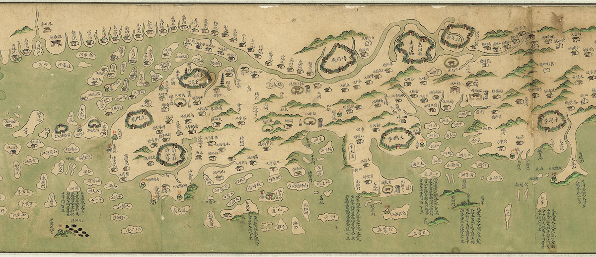
The Walled City stood in what became known after British incursions as the New Territories. Humans had been settling in this vicinity for centuries, including pearl hunters since the Han Dynasty and villagers and long-term residents in the Ming and Qing, and by the mid-18th century, a Qing-imposed system of land deeds administered territorial possessions throughout the area.3 The Qing history of the Walled City must first be explored before the Convention of 1898 can enter into view. Contemporaneous with the Walled City’s earliest fortifications — a signal station in 1668, a beach-facing fort in 1810, and an outer wall with mounted cannons in 1847 — the wider New Territories area housed villages and settlements inhabited by ethnic Punti and Hakka (Figure 2) (Krone 1859: 100–101).
Containing not only a wall to give it shape and cannons for defense, but also offices and military barracks, the Walled City functioned as a garrisoned district during the Qing, responsible for overseeing villages in its vicinity as well as for keeping watch over the British presence in Hong Kong, which, by 1841, had begun its colonial possession of Hong Kong Island (Krone 1859: 100–101). Before 1898, the Walled City’s function was primarily administrative rather than residential. In the 1890s, it housed only about 200 civilians but more than 300 Qing officials, military personnel, and their dependents, including the xunjian (巡檢 deputy magistrate) and the commodore of the Dapeng Brigade, the area’s head bureaucrat and military official respectively (Lockhart 1898: 75; Sinn 1987: 32). The former’s office was a yamen, which remains standing even today, and which served as a center for local governmental affairs within Xin’an County, a territorial entity in place since the Ming.4 The Walled City yamen was similar to those in other walled cities throughout Qing China. These administrative complexes operated throughout the Qing period, allowing the dynasty’s outsider Manchu rulers to govern rural Chinese society using elite Chinese magistrates as their intermediaries (Watt 1977: 357). In other words, the function-defining feature of imperial walled cities was their yamens, rather than the walls that gave walled cities their names and sense of boundedness.
Graphic representations of Guangdong Province from the Qing reinforce this argument. In a watercolor map of coastal Guangdong, produced around the 19th year of Emperor Daoguang’s reign (circa 1839), islands and peninsulas are dotted with green-roofed buildings, indicating yamens (Figure 3). In addition to these yamen icons, larger walled cities are depicted with thick, elevated outer walls to indicate the presence of substantial garrisoned enclosures. These wall icons occur with less frequency, with only ten drawn throughout the entire map. Fourth from left among these ten wall icons is Xin’an County’s central walled city, featuring four gates and the label ‘Xin’an County Xin’an Barracks (新安縣 新安營)’. The Kowloon Walled City, in contrast, is farther to the right, its modest yamen icon framed by nothing more than islands, waterways and its corresponding label, ‘Kowloon Bay Garrison (九龍湾汛)’.
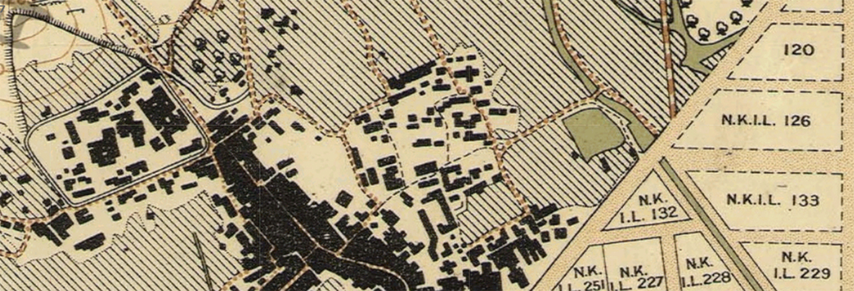
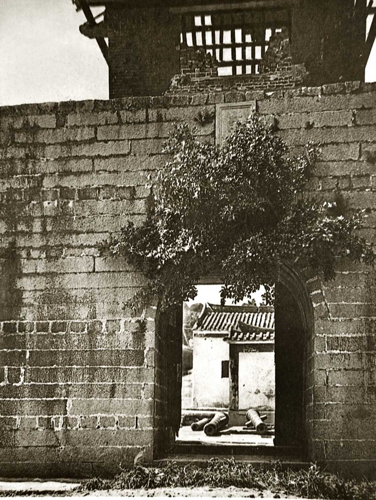
Serving as further evidence that the Walled City’s wall was of secondary importance compared to its yamen, few of its specific measurements were recorded until after the Convention of 1898. A reconnaissance mission by JHS Lockhart in 1898 showed that it spanned 6.5 acres and stretched 700 feet by 400 feet in a rectangular formation, with another triangular portion extending up a hill (Lockhart 1898: 74–75; Ho 2021). Surveys done in the next decade reveal a similar shape (Figure 4) (‘1900–1902 Survey’, 1902).5 According to Lockhart, the wall’s height measured 13 feet, although later accounts place this figure as high as 23 feet. Encircling the entire perimeter of the Walled City in granite ashlar, it also included six watchtowers and four gates, one of which was a main gate on the southeast corner (Figure 5) (Sinn 1987: 31).
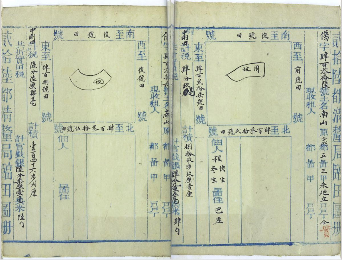
Chief among the administrative concerns of the Walled City yamen was land, with jurisdiction over Xin’an County consisting of three processes: grants, taxes, and reclamations. Under the Qing Imperial Land Law, the emperor held claims over all arable land, with imperial grants allowing for ‘perpetual imperial tenancies’ (Hase 2013: 25). Proof of these land grants was established through tax collection, in which the yamen played a direct role. Research into the social history of taxation in mid-19th-century Guangdong Province shows that taxes were paid either to traveling yamen representatives — tucha (圖差), as they were sometimes called, who were hired workers that made house calls to the vicinity — or at the local yamens directly (Matsubara 2011: 179). As for reclamations, they addressed instances in which inhabitants wished to claim new land from the emperor’s holdings. Reclamation procedures depended upon the sizes of land plots in question, but were also officiated through tax payments to yamens (Hase 2013: 28). In principle, the system underpinning grants, taxes, and reclamations in Qing-era Guangdong was a Ming-inherited land scheme known as yulin tuce (魚鱗圖冊), the ‘fish-scale register’ (Matsubara 2011: 173). Tracking the shapes, place names, tenants, borders, measurements, and areas of taxed land, these registers were arranged in plot-by-plot records and stored at their respective yamens (Figure 6).
By the waning years of the Qing, land records held at yamens or by officials did not reflect all-encompassing landholding arrangements. In the absence of registers supplying comprehensive information, deeds exchanged during tax transactions conducted at yamens or by yamen-appointed representatives did so, describing locations and borders of properties (Matsubara 2011: 173, 167). Thus, in one way or another, even when records existed in decentralized deed forms, land transactions always connected back to yamens. For the Walled City yamen, as the political identity of its surrounding area shifted from Xin’an County to the British colony of Hong Kong, the Qing land deed system would also be renegotiated in new terms.
The Convention of 1898, Land, and Architecture
Deed-based, decentralized transactions simultaneously affirmed the administrative importance of the Walled City yamen, minimized the need for comprehensive visual records of land plots, and undermined the importance of pictorial and cartographic accuracy in and of itself. However, as Qing–British conflicts continually redefined Hong Kong’s borders in the decades leading up to 1898, maps played an increasingly prominent role in political negotiations and their consequent changes to land. Maps thus highlight a contrast between the yamen’s land practices and those later adopted in colonial Hong Kong. As argued by Latour, printed maps are ‘immutable mobiles’. Printing presses achieve immutability because they create identical copies of visual matter — the ‘perspective, projection, map, log book’ — and ensure their unchanging character. Meanwhile, mass production provides mobility, since it makes replicable objects and guarantees their portability. Latour maintains that maps completely modify ‘links between different places in time and space’, since these image-based representations ‘circulate everywhere and in all directions in Europe’ (1986: 7–8, 11).
Although Latour’s post-Renaissance focus overlooks a longer history of cartographic developments in the greater Chinese region, his argument can still be used to describe a key shift in how New Territories land was understood and administered after the Convention of 1898. Within this treaty, as well as in the cadastral surveys carried out on its heels, map-based representations declared and reaffirmed boundaries and relationalities between tracts of land. In this way, the proliferation of maps as ‘immutable mobiles’ in turn-of-the-century Hong Kong coincided with and indeed aided changes to land organization therein. Rather than decentralized transactions conducted at or near the Walled City yamen, the ‘immutable mobiles’ of maps — immutable in their printed and reproducible mediums and mobile in their presence in treaties, in guidebooks, and in other formats — narrated shifts in land administration that, in turn, changed the very uses of Walled City land.
The Convention of 1898 was among the ‘unequal treaties’ signed between Western powers and Qing China in the decades after the First Opium War. The treaty increased the territorial presence of foreign governments and decreased Chinese autonomy in trade (Wesley-Smith 1980: 9). Hong Kong Island was the first site ceded to Britain. In effect, the island came under British control in 1841, while the formal decree arrived the following year via the Treaty of Nanking. Two decades later, in 1860, the Convention of Peking added Stonecutters Island and the south end of Kowloon Peninsula to the colony. The Convention of 1898 involved the largest amount of land: the entire mainland region to the north of Boundary Street on the Kowloon Peninsula, between Deep Bay and Mirs Bay on its eastern and western ends, as well as various islands near existing colonial possessions. While the Treaty of Nanking, as well as the Convention of Peking, had granted a territorial cession ‘in perpetuity’ (Treaty of Peace, Friendship, and Commerce 1842: 9), the Convention of 1898 stipulated only a temporary lease. This non-permanency — a 99-year lease that would expire in 1997 — granted a continuity of land-use for areas ceded in 1841 and 1860 and acknowledged the New Territories’ leased nature.
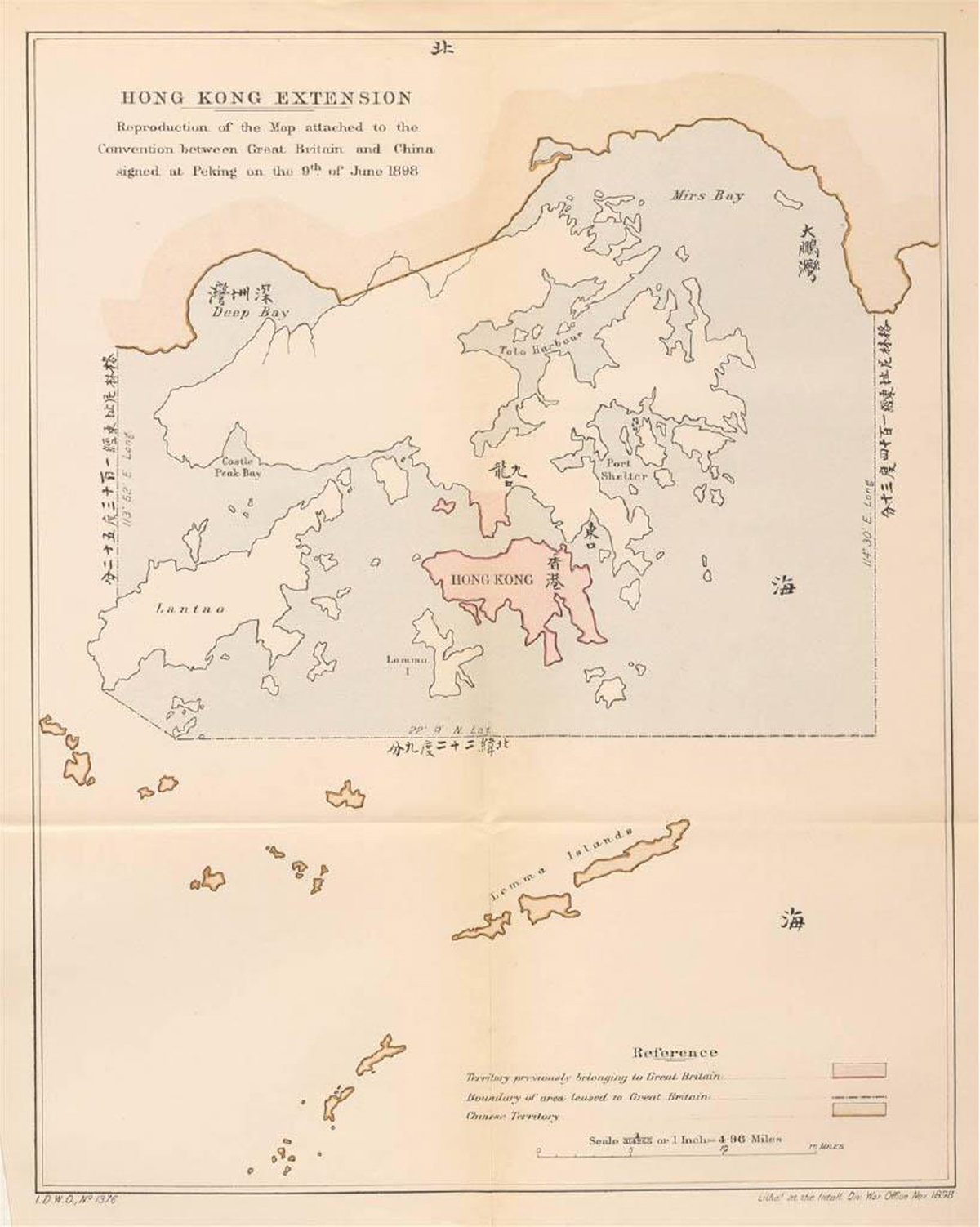
The Convention of 1898’s descriptions of the land transactions were accompanied by a printed map depicting the changes. In text and image alike, this treaty specifically addressed the Walled City, highlighting its administrative centrality within the wider New Territories area. Indeed, Guo Jiahong has emphasized the extent of Qing-British contestation over the Walled City’s jurisdiction, both in prior negotiations as well as in this treaty, due to the yamen’s status as the political heart of the surrounding area (2017: 59). These tensions resulted in the Walled City being treated within the Convention of 1898 as an uneasy exception to the New Territories’ leased nature. ‘Within the city of Kowloon’, the text states, referring to the Walled City, ‘the Chinese officials now stationed there shall continue to exercise jurisdiction except so far as may be inconsistent with the military requirements for the defense of Hong Kong’ (Convention Between the United Kingdom and China 1898: 1). The treaty’s map similarly singled out the Walled City, labeling it with a dark square and a textual annotation, 九龍, meaning Kowloon, conferring upon it the same visual prominence as larger landmarks like bodies of water or entire islands (Figure 7). Officials and other individuals residing within the New Territories were allowed to remain, with no risk of ‘expropriation or expulsion’ (1898: 1). Furthermore, continuity in the activities in and out of the Walled City were also accounted for, with ‘the existing landing-place near Kowloon City [being] reserved for the convenience of Chinese men-of-war, merchant and passenger vessels, which may come and go and lie at their pleasure; and for the convenience of movement of the officials and people within the city’ (1898: 1).
Hong Kong Extension. 1898. From Convention Between the United Kingdom and China, Respecting an Extension of Hong Kong Territory, with a Map (1898: plate 1). London: Printed for her Majesty’s Stationery Office by Harrison and Sons, St. Martin’s Lane, 1898. Plate 1. Charles W. Wason Pamphlet Collection, Cornell University Library, Ithaca, New York.
However, these promises of continuity within the treaty contradict its characterizations of land and architecture, revealing fissures between colonial Hong Kong and that which lies beyond it, between the New Territories and the Walled City. The treaty references structures and infrastructure sporadically in its three pages of English and Chinese text, but only when discussing land outside the Walled City. Concern for the ‘road from Kowloon to Hsinan’, denoting transport links between the Walled City and the rest of the Hong Kong colony in Xin’an County, only applied to areas outside the Walled City itself.6 Likewise, the treaty mentions contingencies for a Chinese-constructed railway — eventually the Kowloon-Canton Railway that took shape a decade later — but only addresses its construction ‘to the boundary of the Kowloon territory under British control’ (Convention 1898: 1). These statements show an undeniable discrepancy between the plentiful, extensive mentions of the Walled City, which take up about half the text, and the complete absence of references to structures and infrastructure within it.
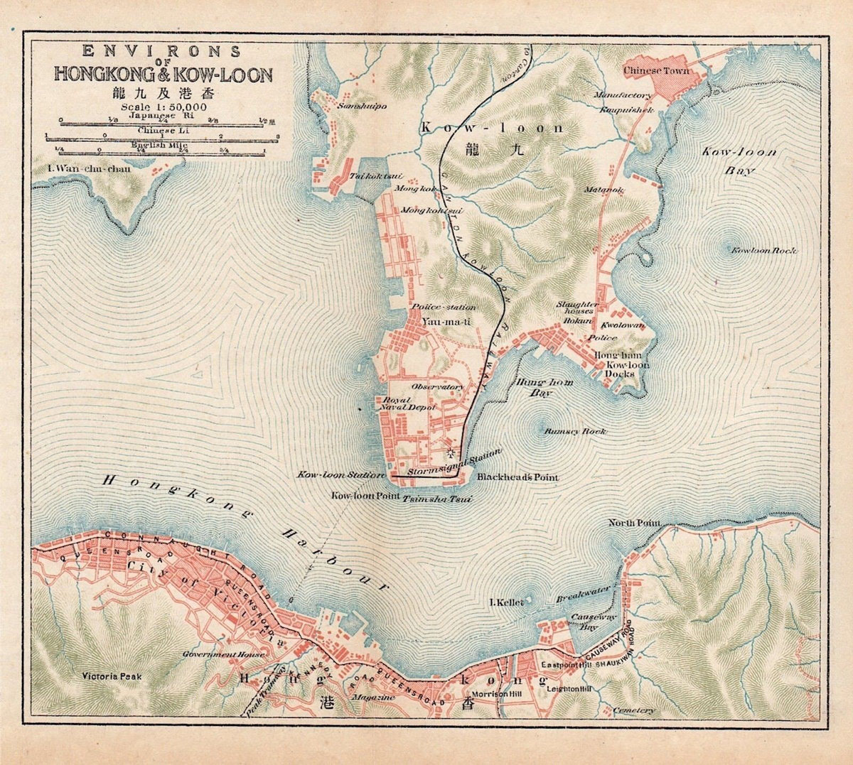
Maps demarcating the first leg of the Kowloon-Canton Railway, completed in 1910, echo this approach. Prepared by the Imperial Japanese Government Railways, one printed map uses a black line to demarcate the rail path from the northern New Territories to the tip of the Kowloon Peninsula, while urban spaces are in orange (Figure 8). The Walled City, far from both the northern Hong Kong boundary and the new railway, is labeled as the ‘Chinese Town’ next to Kowloon Bay. There are no visual cues to signal that the ownership and administration of the ‘Chinese Town’ was different than other areas of Hong Kong. It is not, however, drawn with the same level of detail as other parts of the map. The jagged borders of the ‘Chinese Town’ do not correspond to the outer walls of the Walled City, encompassing instead some of the built space outside its actual walls. No roads or land lots are indicated, and nothing breaks up its mass of orange. In contrast, at the southern tip of the Kowloon Peninsula, individual land lots form neat rectangles along the waterfront. Across the harbor in Hong Kong Island, street names are even labeled, with the winding expanse of Queen’s Road traceable across the ‘City of Victoria’.
Environs of Hong Kong & Kow-Loon. 1915. 1: 50,000. From The Imperial Japanese Government Railways, An Official Guide to Eastern Asia.
While the Walled City’s structures and infrastructure were often glossed over in textual accounts and pictorial representations alike, Victoria and other British-controlled areas were given different treatment, beginning in the early years of British incursion on Hong Kong Island. Officially codified as a city and otherwise regarded as an urban area since the mid-19th century, Victoria boasted the longest history of British settlement of all the land encompassing the Hong Kong colony. Recollecting his first impressions of Hong Kong in 1844, Arthur Cunynghame, an aide-de-camp to Major-General Alexander Fraser, commented on its new buildings:
Perhaps no place in the history of ages can boast of such a rapid rise as the town of Hong-Kong. In August, 1841, not one single house was yet built, not a portion of the brush-wood had been cleared away from this desolate spot. By June, 1842, the town was considerably more than two miles long, containing store-houses and shops. … The town already boasted of 15,000 inhabitants, and it was almost impossible to prevent the people from the opposite coast from flocking to us. (Cunynghame 1844: 83)
Cunynghame’s account sets up a contrast between Victoria’s rapid urbanization and its nebulous ‘opposite coast’, defined not by its buildings but by its émigrés (1844: 83). Similarly, the Convention of 1898 was pointedly vague about the makeup of New Territories land, including the architecture that sat upon it. It mentioned the lack of ‘exact boundaries’ for the whole New Territories area and for the smaller divisions within it, declaring that further details would be settled ‘when proper surveys have been made by officials appointed by the two Governments’ (Convention 1898; Ho 2021).
Cadastral Surveys and Land Management in Colonial Hong Kong
The same year that the Convention of 1898 was signed in Beijing, a major British cadastral survey took place in Egypt, eventually producing twenty thousand maps that depicted the country’s farmable land foot-by-foot, plot-by-plot, and region-by-region, at a 1: 2,500 scale (Mitchell 2002). Cadastral surveying commenced in Hong Kong shortly after the Convention of 1898. The surveys kicked off in full force in 1900, when a British-Indian surveying team arrived by sea from India, where the team’s leads, George P. Tate and W.J. Newland, had recently engaged in similar work (Cheung 2017: 136). Tate and Newland’s efforts focused on two projects: a topographical survey recorded at a 1: 63,360 scale and a fiscal survey of all the occupied land within the New Territories, first begun at a 1: 3,960 scale, but later expanded to a 1: 1,980 scale for the majority of lots surveyed (Department of Land Surveying and Geo-Informatics).
To produce these New Territories surveys, colonial authorities recruited New Territories residents to serve as ‘demarcators’ and to perform roles equal parts manual and translational (Department of Land Surveying and Geo-Informatics). The primary sources of information for these surveyors and their demarcators were the local inhabitants themselves. As a 1904 survey report recounted, the demarcator teams ‘marked the various holdings as pointed out by the tenant’ (Newland 1904; Leung, Sham, and Tang 2008: 31). Then they would lay bamboo along the edges of individual land lots, assign them lot numbers, and gather details about size and occupancy. Surveyors would then compile this information into fiscal survey maps. This workflow included direct contact with occupants and their land but entirely bypassed the Qing land deeds system. In fact, the kind of information contained on land deeds and yulin tuce, the documents that were in theory archived at, and in any case in practice dependent upon, the Walled City’s yamen, were similar in nature to the content of fiscal surveys conducted in the British-Indian cadastral efforts. Thus, the cadastral system circumvented older structures of organizing land — an epistemological bypass — as well as older sites on which such structures were centered — a spatial bypass.
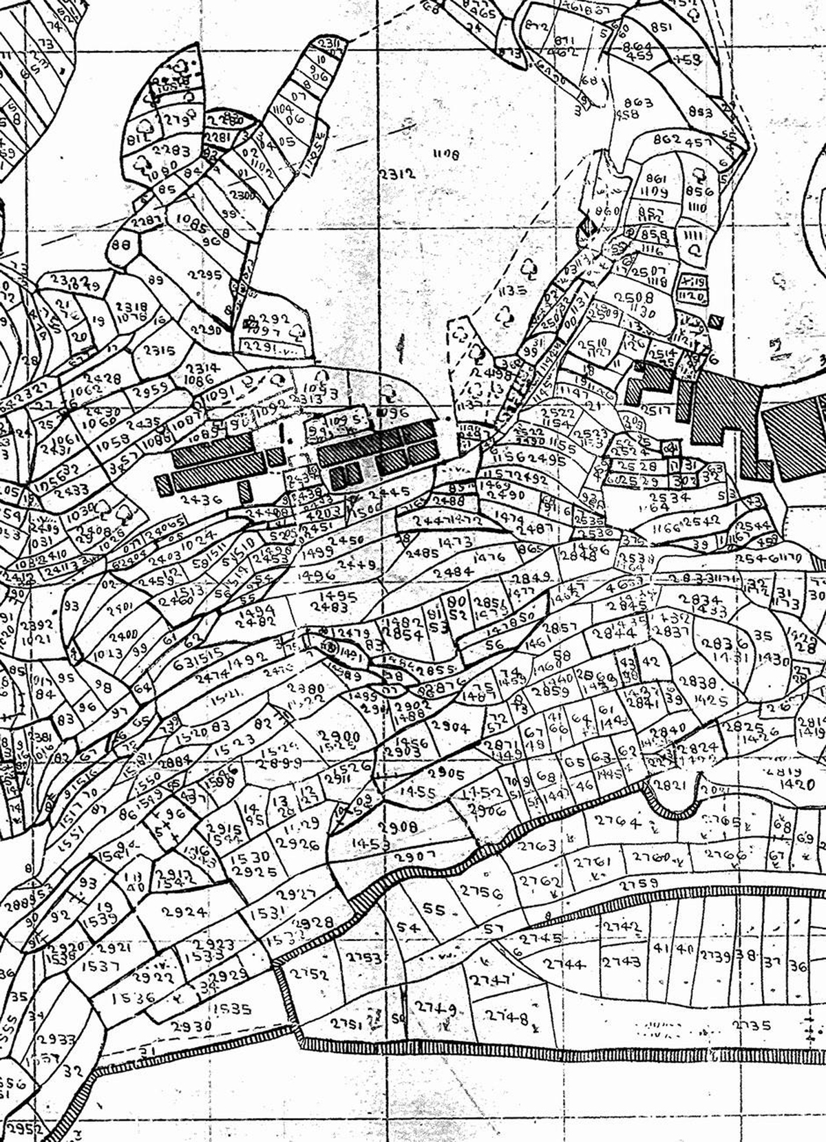
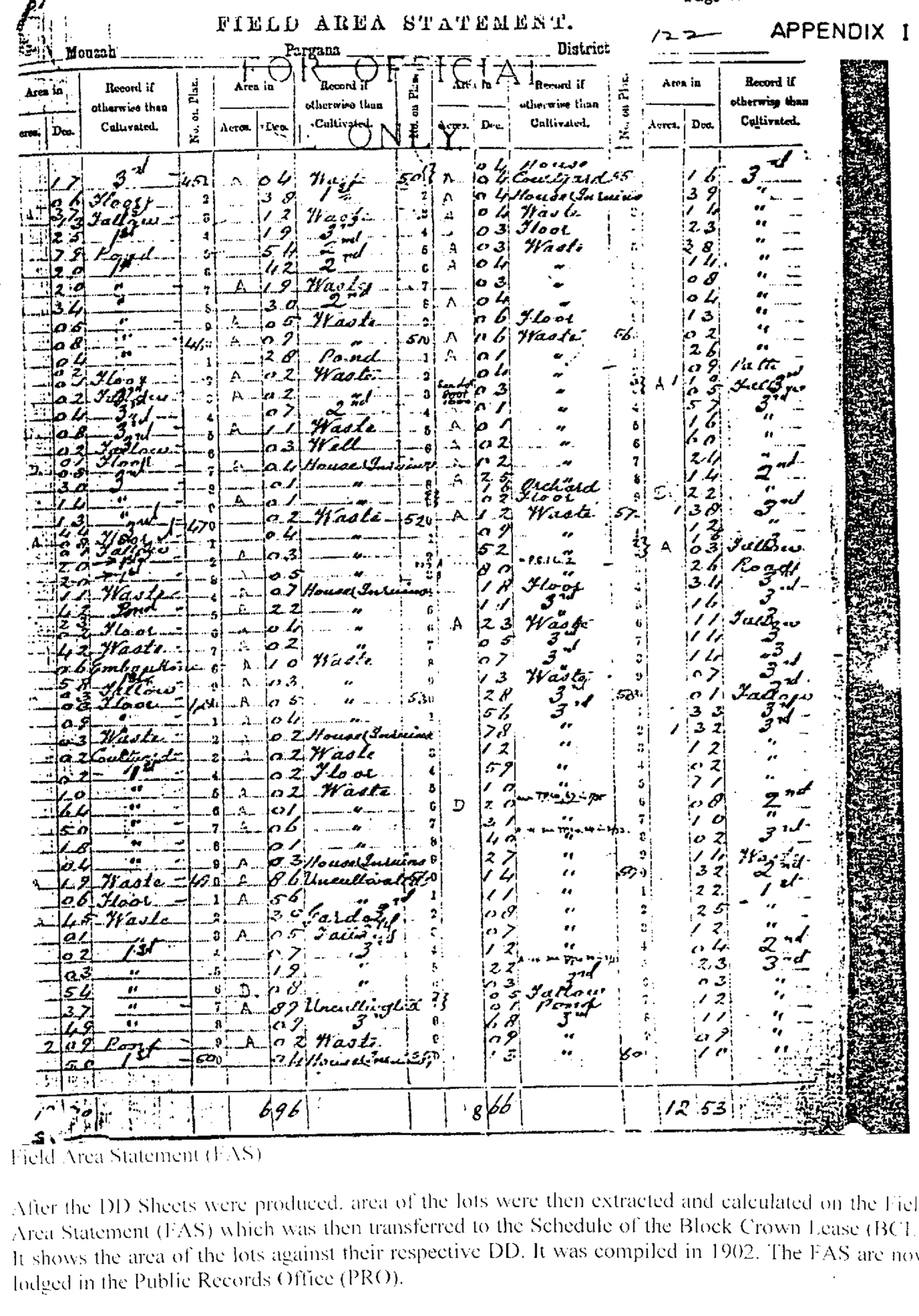
Maps cemented the cadastral system’s epistemological bypass, introducing image-based records as a replacement for the Qing land deeds system. The maps made during these post-1898 surveying efforts were not only mobile, in Latourian terms, but also aided in the production of additional, equally portable information about New Territories land. On non-fieldwork days, surveyors would compute lot sizes based on newly created maps known as Demarcation District sheets (Figure 9). These calculations would then be transferred out of map form and into tables known as Field Area Statements (Figure 10). After this map-to-table transfer, information from Field Area Statements was further transposed onto documents called Block Crown Leases, which became the region’s official land tenancy documents when the Hong Kong government formally enacted the New Territories Land Ordinance in August 1905 (Department of Land Surveying and Geo-Informatics). From Qing land deeds to the British cadastral system, land knowledge moved from the entry-based records of yulin tuce to visual maps and then back again to new entry-based records.
Demarcation District Sheet. 1899. Department of Land Surveying and Geo-Informatics, Hong Kong Polytechnic University, http://cadastre.lsgi.polyu.edu.hk/1898.html.
Field Area Statement. 1902. Department of Land Surveying and Geo-Informatics, Hong Kong Polytechnic University, http://cadastre.lsgi.polyu.edu.hk/1898.html.
The production of new maps after 1898, juxtaposed with the continued reliance on entry-based records, albeit new ones calculated afresh from cadastral surveys, raises the question: Were the time-space connections of the New Territories radically changed? Here, Latour’s conception of the immutable mobile undergoes a necessary complication. Although the British cadastral system bypassed the older Qing land deeds system, its reliance on entry-based information in the form of Field Area Statements and Block Crown Leases was not a significant departure from past modes of land knowledge. Furthermore, its process of converting between maps and table entries introduced interpretive discrepancies and weakened the notion of immutability, since the accuracy of Demarcation District sheets could only be corroborated with the help of control points, but changes to control points could not retroactively be logged on Demarcation District sheets. Thus the most enduring change after the New Territories were incorporated into the Hong Kong colony in 1898 was not an epistemological bypass brought on by cadasters, but rather a spatial bypass related to the Walled City’s yamen.
With cadastral surveys and Block Crown Leases replacing Qing land deeds, the original functions of the yamen were all but neutered, the Walled City bearing witness to a clash of empires. Between the Convention of 1898 and the formal end of Qing China in 1912, as cadastral surveys were being carried out and rendered official in the New Territories Land Ordinance, the Walled City underwent a series of changes. After the Convention of 1898, the governor-general of Guangxi and Guangdong sent 600 troops into the Walled City to defend its treaty-stipulated Chinese jurisdiction, a move that alarmed the Colonial Office. With reports emerging from both sides about plain-clothed Qing officers and soldiers stationed in the Walled City, the situation came to a head on May 16, 1899, when the Hong Kong government dispatched British-trained militia forces to the contested territory (Liu 1994: 7). The move was swiftly followed by an Order-in-Council that aimed to ‘legalize’ the Qing removal and announce ‘British jurisdiction over the Walled City’ (Sinn 1987: 37). It acted as a paper edict meant to override the earlier paper edict of the Convention of 1898, although the Qing government never formally recognized this later Order-in-Council.
Following these events, the Walled City became what Sinn calls a ‘near vacuum of administrative function and authority’ (1987: 38). According to the Convention of 1898, the last jointly ratified treaty, it was still under the purview of Qing China, but as per the unilateral Order-in-Council issued a year later, it was under a 99-year lease by the British Crown, like the rest of the New Territories. By the turn of the century, its population had been depleted and its buildings emptied, a stark reality that corroborated its ambiguous status. Contradictions that existed in the legal jurisdiction of the Walled City also played out in its land management. Under the older Qing land deeds system, the Walled City — and especially its yamen — served as an administrative center. However, under the newer British cadastral system, its previous functions ceased to exist while the surrounding region’s new designations of lots and Block Crown Leases excluded Walled City land. Legal ambiguity and physical decay punctuated the consequent architectural history of the area.
The shift from Qing land deeds to the British cadastral system saw the latter replace the former across the New Territories. To facilitate this switch and troubleshoot discrepancies at the tenant level, a Land Court’s office was set up in the Walled City’s former Lung-chin Communal School from 1900 to 1905 to register land tenancy and process old land deeds linked to New Territories villages. Functioning with not quite the authority of the old yamen, but with the same spatial centrality, the Land Court processed settlements and claims related to plots gathered in cadastral surveys (Department of Land Surveying and Geo-Informatics).
During surveying, land tenants were given siuchi (小紙), small papers bearing lot and serial numbers (Hayes 2012: 297).7 These documents were but another measure enacted to overhaul and replace Qing land deeds, logging additional information regarding the sizes and locations of land plots. In some cases, tenants made appearances at the Land Court with their Qing land deeds and siuchi to dispute claims; in others, bureaucrats known as Assistant Land Officers made house calls, just like in the old yamen system. As Hayes (2012: 297) describes, siuchi documents were codified as part of Hong Kong’s broader cadastral records. One New Territories resident’s siuchi helps illustrate the process:
Mr. Chan’s ten ‘Chi Tsai’ [a colloquial term for siuchi] related to the land claimed by his father Chan Sai-wing, and all bore his name. No one had contested his claim, and his ownership of these lots was later confirmed to the schedule of Crown lessees to the Block Crown Lease for the relevant survey district (No. 436). (Hayes 2012: 297)
After most land issues in the New Territories were resolved in 1905, the Land Court’s physical site was no longer necessary, and it closed, just like the yamen before it. Thus concluded the new system’s bypass of the old, epistemologically as well as spatially.
From the Yamen to the Wall: Defining the Interior via the Exterior Post-1898
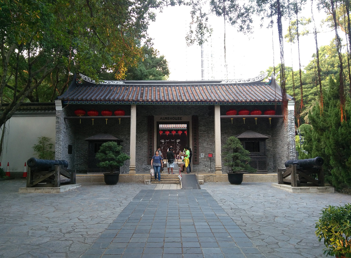
While the new British cadastral system governed leases for the rest of the Hong Kong colony, the tenancy in the Walled City was handled with more ambiguity, owing to the contested jurisdictional authority of the area. With most of the former Walled City organizations and inhabitants forced out, its structures were leased in five-year cycles, made intentionally short as a contingency measure. After the Land Court moved out, the building of the former Lung-chin Communal School was used as a free secondary school as well as a part-time medicine dispensary (Sinn 1987: 38). Similar informal adaptive reuse schemes popped up throughout the area, with the buildings all being put to public-facing purposes: the former San-sheng Temple became an Anglican chapel; the office of the Commodore of the Dapeng Brigade was used as a plague hospital; and Qing administrative buildings, including the yamen, the old bureaucratic heart of the Walled City, housed old people’s shelters, almshouses, and orphanages (Sinn 1987: 38–39). Enduring a better fate of preservation than most other structures around it, the yamen, to this day, bears a plaque with the inscription ‘ALMSHOUSE’, acknowledging both its first and second lives as public institutions (Figure 11) (Hong Kong Leisure and Cultural Services Department).
Y. S. Tsoi. Yamen — Kowloon Walled City Park — Yamen. 2017. https://flic.kr/p/H6fh2c/. Creative Commons license at https://creativecommons.org/licenses/by/2.0/legalcode.
Throughout this post-1898 architectural repurposing, the Walled City’s outer wall remained standing. As mentioned earlier, land management under the British cadastral system excluded the Walled City. However, during the cadastral surveying effort at the turn of the century, it was studied via a ‘special survey’ with wall coordinates ‘made and plotted’ alongside other cadastral units (‘Report of the Director of Public Works for 1900’, 1901). Its outer wall was treated as its ‘official boundary’, giving identity to the spaces that lay within, and this rectangular-triangular enclosure also rendered its bounded area a ‘de facto cadastral unit’ (Lai 2016: 96). Furthermore, Lai’s work with map comparisons and GIS has shown that after the Hong Kong government’s 1899 Order-in-Council, it treated the Walled City like a ‘de jure Hong Kong territory’ despite the clear boundaries of the outer wall weakening this position (2016: 96). Thus, the clash of land systems can be distilled into a tension between the de jure, the de facto, and the wholly illegitimate. Although the Hong Kong government regarded the Walled City as a de jure part of its colonial territory after 1898, the area’s architectural use reflected a more precarious, illegitimate position. Simultaneously, the Walled City was not assigned official lot numbers during cadastral surveying, but the presence of lots everywhere else in the colony reduced the site to a de facto cadastral unit. Amid these contradictions, the outer wall preserved the unity of the Walled City, a unity present since before the New Territories was under British rule.
Within the walls, the area underwent significant changes in the early 20th century. Qing China ceased to exist after 1912, so its regime no longer laid claim to the Walled City’s land. Civil strife during the fall of the Qing empire and the advent of the Republic of China brought waves of refugees to the Hong Kong region, and by the 1930s, settlement in the Walled City numbered over 2,000 residents and 100 households (Lu 1988: 90). At the same time as its population swelled, threats of demolition grew. In 1933, the Hong Kong government, in agreement with Republican China, proposed a plan to clear all residents and establishments from the Walled City and turn its premises into a city garden (Lai 2016: 96). Space-clearing continued into the next decade. When the Japanese occupation of Hong Kong began in 1941, bricks and the outer wall were repurposed as construction material for the nearby Kai Tak airport (Liu 1994: 15). In the mid-20th century, through structural demolition, residential relocation, and subsequent repopulation, the contestation over the area effectively ended, with scholarship on this era of the Walled City’s history emphasizing its ‘interdependence’ with Hong Kong (Harter 2000: 96).
The Walled City’s history of contested jurisdictions — of the Qing land deeds system being replaced by the British cadastral system in the New Territories, as well as of the ambiguity cast upon the former Qing garrison and administrative heart during the transition — centered on the organization and tenancy of land. In turn, the structures that sat upon this land made legible, if not directly shaped, both systems. Under Qing land deeds, the Walled City’s yamen regulated taxation operations, housing the offices of Qing officials, processing deed records, and acting as a meeting point between villagers and the local government that oversaw them. During the New Territories’ incorporation into the British crown colony of Hong Kong, another architectural feature defined the area and gave it order in accordance with the cadaster-divided land around it: the outer wall. The early architecture of the Walled City thus outlived its original uses. Its ghosts lingered throughout Hong Kong’s inhabited areas, throughout the varying densities of the Walled City, throughout, even, its century-and-a-half of residential and institutional life.
Notes
- The pinyin system of translation is used throughout this text, except in cases where proper nouns are more commonly romanized in other ways that are consistent with their historic and linguistic use, such as ‘Hong Kong’, ‘Kowloon’, etc. [^] [^] [^] [^] [^] [^] [^]
- The Kowloon Walled City will hereafter be referred to as the ‘Walled City’.
- Relevant to these histories, Kentaro Matsubara (2004; 2009) has done extensive work on land markets in Qing South China, with a special interest in Guangdong Province, including Hong Kong’s New Territories. The evolution of Qing land deeds after the introduction of the British cadastral system has also been studied by James Hayes (2012).
- The county’s romanization has been inconsistent throughout its history. ‘Hsin-an’, ‘Sanon’, and ‘Sunon’ have also been used in place of Xin’an (寶安縣) (Hayes 1974: 111; Mao and Jun 1865).
- This survey dates to 1900–1902, and it became part of the first 1904 cadastral survey of the New Territories.
- ‘Hsinan’ is a romanization of Xin’an under the Wade-Giles system.
- Siuchi (小紙), otherwise romanized as siuzi or siutsi, is the Cantonese transliteration of the term. Xiaozhi (小紙) would be the pinyin Mandarin Chinese romanization of small papers.
Acknowledgements
I wish to thank the staff of the Hong Kong Public Records Office, the Hong Kong Museum of History, and the British National Archives for their assistance, as well as the Paul Mellon Centre for Studies in British Art, whose funding supported the archival trips that form the basis of this research. I am also grateful to the organizers and coordinators of the 2021 IFA-Frick Symposium on the History of Art for their invitation to present a version of this text. Additionally, thanks go out to Zeynep Çelik Alexander, in whose seminar my ideas for this article first germinated; Barry Bergdoll; my writing group on architecture and empire; the peer reviewers and editors at Architectural Histories; and various other colleagues who offered feedback on earlier drafts of this article.
Competing Interests
The author has no competing interests to declare.
References
Unpublished Sources
1900–1902 Survey, District 1, Sheet 2. 1902. Series 129. Great Britain Colonial Office.
Lockhart, JHS. October 8, 1898. Lockhart to Chamberlain. Original Correspondence. Series 129. Great Britain Colonial Office.
Report of the Director of Public Works for 1900. 1901. Hong Kong.
Published Sources
Barber, LB and Chu, CL. 2020. Living Heritage Versus Dead Relics? Place Meanings and Boundary-Making in the Politics of Heritage in Postcolonial Hong Kong. In: Kopec, D, and Bliss, A (eds.), Place Meaning and Attachment, 182–193. New York: Routledge. DOI: http://doi.org/10.4324/9780367232689-15
Cheung, SW. 2017. Colonial Administration and Land Reform in East Asia. London: Taylor & Francis. DOI: http://doi.org/10.4324/9781315186702
Convention between the United Kingdom and China, Respecting an Extension of Hong Kong Territory, with a Map. 1898. London: Harrison and Sons. Charles W. Wason Pamphlet Collection, Cornell University Library, Ithaca, New York.
Cunynghame, AAT. 1844. An Aide-de-Camp’s Recollections of Service in China, a Residence in Hong-Kong, and Visits to Other Islands in the Chinese Seas, Vol. 1. London: Saunders and Otley.
Cushman, C. 2018. Temporary Ruins: Miyamoto Ryūji’s Architectural Photography in Postmodern Japan. Thesis (PhD), Columbia University. DOI: http://doi.org/10.7916/D83B7GKG.
Department of Land Surveying and Geo-Informatics. n.d. History of HK Cadastral Survey System. The Hong Kong Polytechnic University. Accessed July 9, 2019. http://cadastre.lsgi.polyu.edu.hk/history.html.
Guo, J. 2017. Jiulong Chengzhai Gang Ying Jishou Bainian de ‘Feidi’ 九龙城寨港英棘手百年的‘飞地’ (Kowloon Walled City, Hong Kong, a Century-Long Thorny ‘Enclave’). Wenshi Jinghua 文史精华 [Gems of Culture and History], 20: 58–63.
Harter, S. 2000. Hong Kong’s Dirty Little Secret: Clearing the Walled City of Kowloon. Journal of Urban History, 27(1): 92–113. DOI: http://doi.org/10.1177/009614420002700106
Hase, PH. 2013. Custom, Land and Livelihood in Rural South China: The Traditional Land Law of Hong Kong’s New Territories, 1750–1950. Hong Kong: Hong Kong University Press. DOI: http://doi.org/10.5790/hongkong/9789888139088.001.0001
Hayes, J. 1974. The Hong Kong Region: Its Place in Traditional Chinese Historiography and Principal Events Since the Establishment of Hsin-an County in 1575. Journal of the Hong Kong Branch of the Royal Asiatic Society, 14: 108–35.
Hayes, J. 2012. ‘Small Papers’: More on the New Territories Cadastral Survey and Settlement of Titles to Land 1900–05. Journal of the Royal Asiatic Society Hong Kong Branch, 52: 297–300.
Ho, S. 1993. An Architectural Study on the Kowloon Walled City: Preliminary Findings. Hong Kong: William Stout Architectural Books.
Ho, DY. 2021. Hong Kong, China: The Border as Palimpsest. Made in China Journal 5(3): 94–101. DOI: http://doi.org/10.22459/MIC.05.03.2020.13
Hong Kong Leisure and Cultural Services Department. n.d. The Yamen. https://www.lcsd.gov.hk/en/parks/kwcp/yamen.html.
Krone, Rev. 1859. A Notice of the Sanon District. China Branch of the Royal Asiatic Society Transactions, 6: 71–105.
Lai, LWC. 2016. Un-Forgetting Walls by Lines on Maps: A Case Study on Property Rights, Cadastral Mapping, and the Landscape of the Kowloon Walled City. Land Use Policy, 57: 94–102. DOI: http://doi.org/10.1016/j.landusepol.2016.05.022
Lai, LWC and Chua, MH. 2018. The History of Planning for Kowloon City. Planning Perspectives, 33(1): 97–112. DOI: http://doi.org/10.1080/02665433.2017.1331751
Lambot, I, Girard, G and Wilkinson, J. 1999. A Chinese Magistrate’s Fort. In Girard, G (ed), City of Darkness: Life in Kowloon Walled City. London: Watermark. pp. 60–71.
Latour, B. 1986. Visualization and Cognition: Thinking with Eyes and Hands. Knowledge and Society: Studies in the Sociology of Culture Past and Present, 6(1): 1–40.
Leung, SC, Sham, TFP and Tang, CHW. 2008. The Reality Versus the Legality of the Demarcation District Sheets. Surveying and Built Environment, 19(1): 26–37.
Liu, S. 1994. Jiulongcheng Wenti Shimo 九龙城问题始末 (The Kowloon Walled City Question from Beginning to End). Jindaishi Yanjiu 近代史研究 [Modern Chinese History Studies], 6: 1–22.
Lu, J. 1988. Jiulong Chengzhai Shihua 九龍城寨史話 [History of the Kowloon Walled City]. Hong Kong: Joint Publishing.
Mao, H and Jun, L. 1865. Guangdong Tushuo 廣東圖説 [Atlas with Commentary of Guangdong]. Guangdong.
Matsubara, K. 2011. Land Registration and Local Society in Qing China: Taxation and Property Rights in Mid-Nineteenth Century Guangdong. International Journal of Asian Studies; Cambridge, 8(2): 163–87. DOI: http://doi.org/10.1017/S1479591411000040
Matsubara, K. 2004. Law of the Ancestors: Property Holding Practices and Lineage Social Structures in Nineteenth Century South China. Thesis (PhD), Oxford University.
Matsubara, K. 2009. The Functioning of a Land Market in Qing South China: Comments on a Set of Guangdong Land Deeds. The University of Tokyo Law Review, 4: 215–22.
Mitchell, T. 2002. Rule of Experts: Egypt, Techno-Politics, Modernity. Berkeley: University of California Press. DOI: http://doi.org/10.1525/9780520928251
Newland, WJ. 1904. A General Report of the Survey of the New Territories from November 1899 to April 1904. Hong Kong Government Gazette. Hong Kong.
Sinn, E. 1987. Kowloon Walled City: Its Origin and Early History. Journal of the Hong Kong Branch of the Royal Asiatic Society, 27: 30–45.
Terasawa, K and Kani, H. 1997. Daizukai Kyūryūjō 大図解九龍城 [Illustrated Kowloon]. Tokyo: Iwanami Shoten.
The Imperial Japanese Government Railways. 1915. An Official Guide to Eastern Asia. Tokyo: The Imperial Japanese Government Railways.
Treaty of Peace, Friendship, and Commerce Between Her Majesty the Queen of Great Britain and Ireland and the Emperor of China. 1842. Nanking.
Watt, JR. 1977. The Yamen and Urban Administration. In Skinner, GW, and Baker, HDR (eds), The City in Late Imperial China. Studies in Chinese Society. Stanford: Stanford University Press. pp. 353–90.
Wesley-Smith, P. 1980. Unequal Treaty, 1898–1997: China, Great Britain and Hong Kong’s New Territories. New York: Oxford University Press.

