Introduction
After the cataclysm that was World War II, a whole new range of opportunities emerged for implementing large-scale architectural and urban planning concepts. After the initial phase of reconstruction of historic city spaces, completely new urban complexes were initiated, fuelled by the economic boom. The idea was to provide a workforce for the growing heavy industry, tackle overcrowding and increase the standard of living of the population. The same rationale prevailed on both sides of the ‘Iron Curtain’, a term whose imaginary boundary is not particularly relevant when we talk about architecture and urban planning. Central and Eastern Europe naturally drew on the experience of modernity already gained in the inter-war period. In addition, the border created by the new political order was never a solid, physical barrier nor even a clearly defined line of ideological separation, so it seems that György Péteri’s term ‘nylon curtain’, derived from the reality of everyday life, is a more adequate description of the divide. Its emblematic transparency and permeability allowed for the globalisation of knowledge across systemic divides (Péteri 2004). In addition, an important factor was that the Communist regime was initially open to modernisation tendencies, driven by the transnational proletariat ideology and the aspiration to bring about a global revolution. The decline of the avant-garde constructivist trends, however, occurred as early as the early 1930s. By the middle of the decade, Soviet communism had evolved into a highly nationalistic, even ethnocentric system. Urban planning and architecture, drawing on progressive ideas in the broad field of housing conditions, took on a markedly conservative and culturally grounded form (Udovički-Selb 2009).
Immediately after wartime hostilities in the Eastern Bloc area had ended, there was a great deal of freedom in design, but by the end of the 1940s and into the 1950s, socialist realism was adopted as the solely legitimate approach to creative work; Poland saw this happen in 1949. Just as in the USSR, architecture and urban planning in Poland were meant to be socialist in content and national in form. The content was to be functional in that it should meet all the needs of the new society. This was consistent with the idea of residential housing developed by modernists in the inter-war period that had originated in the Industrial Revolution. However, the ideological premises had fundamentally changed. The nationalisation of land and the economy meant that large-scale projects could be launched. The newly created living spaces were to define the society’s existence and identity in accordance with the imposed Marxist ideology imposed by the state. Accordingly, the state not only provided citizens with housing and easily accessible employment, but also organised their leisure time, thus gaining full control over their lives (Kotarbiński 1952; Eckhardt 2016: 11–12). As far as form was concerned, it was postulated that architecture of past eras be drawn upon, especially that involving classical order and harmony, with often quite literal references to motifs and elements of particular historic buildings. Systemic relativism came into play here. In the GDR, for instance, Prussian neo-classicism was a source, even while its social and political context was discredited. In Poland, Renaissance models were used, for example, at the same time as such slogans as ‘fighting against the cosmopolitan trends of bourgeois pseudo-inn’ and criticising ‘the backward ideology and culture of the ruling classes’. The intent was to make an individual national contribution to the ‘treasury of all-human culture’ and the cultural community of the socialist nations (Goldzamt 1956: 81–92).
The ideological proponent of the above line of action was the Moscow-educated architect and architectural theoretician Edmund Goldzamt. In a memorandum on Warsaw’s reconstruction submitted to the Central Committee of the Polish United Workers’ Party (PZPR Central Committee), and specifically to Bolesław Bierut, the party’s First Secretary and the then President of the Republic of Poland, Goldzamt wrote:
Architecture is only a means, a tool for carrying out political agendas … Therefore, [planning matters] should be decided in their entirety by the comrades in charge of our entire struggle on the ideological and cultural frontline — by the leaders of the party and the government. (Skalimowski 2021: 175–177)
Needless to say, the approach Goldzamt advocated strongly affected the design sphere. Axiality, symmetry and particular ideological references to tradition brought with it monumentality, which in turn was intended to demonstrate the great potential and strength of the new system (Włodarczyk 1991: 29; Basista 2001: 23). Bierut noted that ‘ideology finds a wonderful form of its embodiment in architecture. What better way to present our goals, than through panoramas and models of new cities’ (Zieliński 2009: 39).
During the period of socialist realism, the political authorities used large urban projects to enhance their image. Whenever a key project was under consideration, discussions were held with members of Poland’s Politburo or the Government Presidium, and their decisions were subject to final approval by Bierut. The president in turn enjoyed the support of Goldzamt, which guaranteed his ideological legitimacy and personal security. Bierut’s comments often contained explicit recommendations. Interestingly, he was much more appreciative of the work of Antonio Corazzi, a 19th-century Italian architect who is best known for his work in Poland, than of the architecture of Moscow and Leningrad. Regarding the enforcement of socialist realism, he declared, ‘Our architects should refer more to the sound traditions of our national architecture’ (Bierut 1949: 27). Bierut participated in the lengthy deliberations with full commitment. The architect Stanisław Jankowski recalled the 1947 meeting concerning the W-Z Route as follows: ‘The president listened very carefully, asking multiple questions, as if a bit embarrassed that he was interrupting us. He would often get up, walk over to the boards, or check the spatial solutions by scrutinising the models. He would also jokingly mock our tables and diagrams’ (Jankowski 1956). Bierut’s individual decisions usually concerned the selection of a variant from a previously prepared set of drafts. This was how he participated in the approval procedure for Warsaw’s flagship projects, such as the Marszałkowska Housing Quarter (Marszałkowska Dzielnica Mieszkaniowa, MDM), but also those regarding the new city of Tychy (Włodarczyk 1991: 95–96).
Urban planning projects in Poland in the second half of the 1940s were directly related to the reconstruction of major urban centres destroyed during the war. In practice, this meant rather casual restorations of historic complexes, such as Warsaw’s Old Town and New Town, or Długa Street in Gdańsk (Wróblewski 2013: 89–95). Alongside such restorations, new urban complexes were being designed. The first and most spectacular ones were created in Warsaw and include Mariensztat (1948–1949), Muranów (1948–1952) and the MDM (1950–1952). However, the Palace of Culture and Science (1952–1955) was to become the key formal and ideologically dominant structure of the capital’s landscape — a high-rise organising the overall city skyline, the idea and form of which were copied directly from Moscow models. However, at the same time, Lev Rudnev, the palace’s designer, also drew many motifs from the most outstanding Polish landmarks, including Kraków and Kazimierz. This inclination towards monumentalism and decorative style was mainly manifested in the design of public buildings. As far as residential developments were concerned, the MDM became the doctrinal benchmark to which smaller urban areas would aspire (Goldzamt 1956: 403–503; Cymer 2020: 65–103).
Due to their central location, these projects were widely used for propaganda purposes by the young socialist state. A similar pattern was followed in the case of two new cities, Nowa Huta and Tychy, designed as exemplars of socialist realist urban planning. These were flagship projects of the Six-Year Plan (1950–1955), the key goal of which was to strengthen Poland’s economic potential and lay the foundations of socialism. Nowa Huta was built near Kraków, in the immediate vicinity of the steelworks complex, while Tychy was intended for the employees of the mines and industrial plants in the central part of the Upper Silesian Industrial Area (Górnośląski Okręg Przemysłowy, GOP). Construction of Nowa Huta began in 1949, almost simultaneously with the imposition of socialist realism, so it had to be an exemplary model of the doctrine. In terms of urban planning and architecture, Nowa Huta, which has been a district of Krakow since 1951 (RM 1951), follows the trend of new cities emerging as part of the great economic programmes of the Stalinist era. The Czechoslovakian cities of Haviřov and Poruba (now a district of Ostrava), and the Hungarian city of Sztálinváros (now Dunaújváros), among others, were all built using the same principle (Toeplitz 1953; Benko 1953; Åman 1992: 148–164; Strakoš 2010; Jász 2018). The new city of Tychy, one the other hand, is an exception. Because its construction began in 1951, somewhat later than that of Nowa Huta, socialist realism was but a stage in its development, serving after 1956 as a starting point for the formation of a modernist city. As a result, the majority of the city seems more akin to Western European models, such as the satellite towns of the London metropolitan area or Stockholm. Tychy’s chief designers, Hanna Adamczewska1 and Kazimierz Wejchert, were familiar with those concepts thanks to the international contacts they established after the political thaw of 1956. The consistent urban development of Tychy continued until the political transformation of 1989, and is a relatively well-discussed topic. Much less research has been conducted on the city’s early years, dating back to the first half of the 1950s.
Current State of Research
The original concepts for Tychy, as well as its first general plan approved for implementation, were not subject to detailed studies. In their texts published after the political thaw of 1956, Adamczewska and Wejchert, the creators of the approved plans for the city, focused on those later modernist solutions, consistently ignoring the strictly socialist realist beginnings of Tychy (Wejchert 1960; Adamczewska 1964; Adamczewska-Wejchert 1965; Wejchert 1969; Adamczewska-Wejchert and Zadrożna [1985]). It was not until new social and political circumstances arose after 1989 that this subject resurfaced. The designers took up the topic of the project’s early days when they were no longer professionally active. Their two-volume publication Jak powstawało miasto [How a city emerged] (1995) is a summary of their Tychy experiences and a voice in the discussion held at the time — a voice they chose to ignore in their later publications (Adamczewska-Wejchert and Wejchert 1995a; Adamczewska-Wejchert and Wejchert 1995b). The political changes of the late 1980s and early 1990s led to a definite rejection not only of the project to build a new city, but also the entire urban planning and architectural heritage of the People’s Republic of Poland. In 1988, the architectural historian and critic Jeremi Królikowski said that ‘the architecture of the socialist city in Poland is a kind of newspeak, a monologue of power towards an incapacitated audience’. His critique referred both late modernism and socialist realism. He described the latter as ‘parasitic on historical forms’ and responsible for their deformation, referring to Nowa Huta as ‘a pitiful caricature of St. Petersburg’ (Królikowski 2020: 45). A number of practicing architects and sociologists, such as Bohdan Jałowiecki, have also commented on the subject, claiming that a reconciliation with the past is necessary to achieve ‘a kind of catharsis’ (Szczepański 1991: 5). The failure of the majority of the projects of this era was attributed to the centrally planned and authoritarian method of generating space. An urban planner was called an ‘actor’, operating within the confines of interests defined by the political authority and the bureaucratic machine, i.e., the state-owned construction companies which decided the locations and construction methods (Bielecki et al. 1990: 14–24). The book Miasto socjalistyczne i świat społeczny jego mieszkańców [The socialist city and the social world of its inhabitants] (1991) by sociologist Marek S. Szczepański was important in shaping a new perception of Tychy. In the preface, Bohdan Jałowiecki explains that Szczepański ‘shows only some of the effects of urban planning based on doctrinaire thinking and the arrogance of the planners wishing to play the role of demiurges of the social world’. Jałowiecki also states, rather pompously, that a city that was ‘meant to be virtually a paradise’ is in fact ‘filled with dread’ (Szczepański 1991: 6).
In the second half of the 1990s, Tychy was gradually starting to be perceived with a certain degree of detachment. The legacy of socialist realism was approached without trying to settle accounts with the past system. The chapter on the creation of the city by Marek Kuszewski and Stanisław Niemczyk that appears in the Tychy monograph (Kuszewski and Niemczyk 1996) is a good example of this.2 Gradually, the architecture and urban planning of the early 1950s came to be evaluated in a more nuanced way. Andrzej Basista elaborates: ‘Today we appreciate the historicism of the 19th century; art nouveau has also gained enormous popularity. For this reason, Socialist Realism is possibly capable of inspiring affection, too’. Basista also expresses the opinion that buildings created in the 1950s often outshine the later achievements, which is particularly evident in Tychy and Nowa Huta (Basista 2001: 27). After 2000, Tychy’s socialist realism was ‘domesticated’, largely thanks to the efforts of the Tychy City Museum. Guided walking tours of the oldest urban complexes were held and a number of promotional books published (e.g., Lipok-Bierwiaczonek 2009). As a result of such initiatives, Housing Estate A (1951–1956), the first settlement of the new city, was included in the Municipal Register of Heritage Assets of the City of Tychy that was created in 2013. The second settlement, Housing Estate B (1953–1960), was entered into the register in 2017. In the context of the ongoing revision of views on the architecture and urban planning of socialist realism, knowledge of Tychy’s examples of the doctrine is still quite superficial. The detached perception of Tychy’s past results in equating the vision of the socialist city mainly with the modernist paradigm. Sławomir Gzell includes Tychy among the concepts that grew out of the ‘last heroic spurt’ of the modernist ideas advocated by CIAM. He juxtaposes the Upper Silesian city with Swedish and British cities, as well as with Chandigarh and Brasília (Gzell 2000: 151; Gzell 2013: 41–42). Tychy as an example of late modernism is indeed comparable to these centres, though only when it comes to its post-1956 concepts. The original ideas and the way in which they transformed into the currently existing reality have fallen into oblivion. The scope of what was actually executed in accordance with the doctrine also needs to be examined. Tychy is an extremely interesting case of a rupture in the doctrine, and the associated questions indeed call for a closer look at the purpose of Adamczewska’s and Wejchert’s efforts. The perceptions of their approach to design have often been oversimplified (especially over the last thirty years) and seen in isolation from the changing circumstances. A key consideration for understanding the architect duo’s creative stance seems to be the concepts they deployed within Housing Estate B.
The Rise of the New City
On 4 October 1950, the Government Presidium passed a resolution on the expansion of Tychy, which effectively meant the creation of a new urban centre in the vicinity of the existing village of medieval origin.3 Initially, what became this new urban centre was merely intended as a back-up facility for a large construction site. References to the past in this case had rather negative connotations. The future was contrasted with the relics of a bygone social system, using the example of the former Ducal Brewery in Tychy, which was nationalised in 1945. The primary objective for the planned city was to ‘improve the living conditions of the working class of the Central Coal Basin by preventing further urban and settlement congestion in the area’. These measures were an integral part of the intensive process of economic development of the new socialist state. Upper Silesian industry urgently needed manpower. Consequently, Tychy was to be expanded to a size of 30,000 inhabitants during the Six-Year Plan, and ultimately to 100,000. It was assumed that the future inhabitants would be employed in coal mines, steelworks and other industrial plants within a 20 km radius from the new city (PR 1950: 882–883).
The provisions of the resolution were based on the guidelines and concept of the regional plan, commonly referred to as the deglomeration plan of the GOP, i.e., the Upper Silesian Industrial Area. Work on it had been conducted since the late 1940s, under the leadership of Romuald Pieńkowski. As a result, the GOP was split into Zone A and Zone B. The former was a proper, central industrial and urban district that included Katowice, Bytom and Chorzów, featuring rich and easily accessible coal deposits as well as a high population density. Zone B surrounded Zone A as an irregular ring. Its population density was lower, and at that time it was only marginally affected by coal mining (Pieńkowski 1952: 21–22). Zone B was where new urban centres were to be established which, according to Romuald Pieńkowski, ‘should not be merely dormitory settlements, but should constitute a fully fledged component of the settlement structure and create new hubs within the administrative and social connection system of the entire settlement complex’ (1952: 23). The environs of Tychy were considered particularly favourable for the these undertakings —in terms of both natural conditions and proximity to the central part of Zone A.
However, the idea of a city being sited in this area was hardly a new one. In the mid-1940s, the German authorities decided that due to the lack of development opportunities for Katowice, the area was suitable for a new capital of the then Upper Silesian Province. The plan envisaged a city of 150,000 to 200,000 inhabitants, intended to provide housing for the workers and administrative personnel of the surrounding coal mines and industrial plants. This German concept, widely known in Poland in the early post-war years, was called Wohnstadt Kattowitz-Sud. It was presented, among others, in the periodical Trybuna Ludu, but for ideological reasons, the fact that it had been designed as a working class settlement was completely omitted (Skulska 1952). The concept was a development of the urban layout of the town of Tychy and fitted in seamlessly with the existing terrain. The highest hill was to become the ‘stadtkrone’, the crown of the city, where the most important administrative buildings and an assembly square for official meetings were to be located. However, planning work was terminated at an early stage due to the increasingly complicated situation on the eastern front. Although the post-war planning concepts, especially the early ones, showed some similarities with those German plans, most emerged in response to the existing transportation and environmental conditions (Węcki 2011: 222–225). The Polish plans, as comprehensive urban planning concepts, differed markedly from the wartime ideas. However, their conceptual premises were very similar — the resolution of the Government Presidium included, for example, the question of the future city taking over ‘part of the central administrative functions relating to the Central Coal Basin, to take the burden off Katowice’ (PR 1950: 883).
Early Concepts
In accordance with the resolution of the Government Presidium that was passed in October 1950, the assumptions and conceptual drafts of the future city were to be completed by 15 January 1951, and the general plan by the end of the same year. With little time to spare, it was imperative that work should begin immediately. The task was entrusted to the Gliwice-based Department of Workers’ Housing Estates (Zakład Osiedli Robotniczych, ZOR); the New City of Tychy (Nowe Miasto Tychy, NMT) design studio, led by Tadeusz Teodorowicz-Todorowski, was established as part of this department. It took them about two and a half months to develop four location scenarios for the future city as well as the city’s first comprehensive concept and preliminary plans for Housing Estate A (Teodorowicz-Todorowski 1987: 13). Parallel to this, preliminary work was carried out in other fields, both practical and conceptual. Land surveys were completed, and technological and economic guidelines were being developed. Interestingly, this was done on the basis of Soviet experiences and economic indicators, especially those of JP Levchenko (1949; AAN, ZOR ZG 1950: 5).
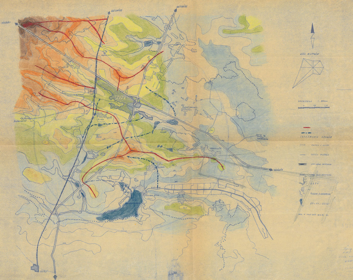
During the design stage, several conferences were held in Warsaw at the level of the Ministry of Urban and Housing Construction, the State Commission for Economic Planning, and the ZOR Board. The technical and economic indicators were also reviewed and evaluated on the basis of Soviet publications by Vladimir G Davidovich (1951) and Levchenko. The preliminary guidelines for the city of Nowa Huta, as well as the norms and planning guidance developed by the Ministry of Urban and Housing Construction were also used as reference (AAN, Ministerstwo Budownictwa 1951). During the Warsaw conferences, specific planning conditions were defined and detailed. The planned city was looked at from the perspective of the existing transportation links, the railway above all, since it was of vital importance for the future residents who were employees of the nearby factories and mines. It was imperative to connect, by means of an electrified railway line, the new city with the Katowice–Bielsko railway line (north–south route) and with its planned west–east extension towards Oświęcim. Another important issue was to integrate the city into the national road network: the Oświęcim-Mikołów route (west–east) and the Katowice–Bielsko route. Just as important as transport were the natural conditions. The areas to the east of the Katowice–Bielsko railway line (Figure 1) seemed to be ideal for future construction. They were topographically suitable and surrounded by sections of dense forest and, to the south, bordered by Lake Paprocany. The potential extent of the future development was also determined by the edge of the areas planned for coal exploitation, to the north of the planned city (Pieńkowski 1952: 21–24; Malisz 1952: 25).
Taking into account the above conditions, the NMT design studio contemplated the previously mentioned four location scenarios for the future city. The highest ratings were given to the second option,4 for a location south of the Mikołów–Oświęcim route, with the planned railway line constituting the northern border of the future settlement area, separating the city from the former village of Tychy. This option, similar to the wartime German plan, became the basis for the development of the initial overall concept of the new city. It was created in two versions — NMT 100, for one hundred thousand residents, and NMT 200, for two hundred thousand. In both cases, Teodorowicz-Todorowski’s concept was based on two axes crossing each other at right angles. Their intersection was at the highest point of the designed city (Figure 2). There, a monumental architectural accent was planned in the form of a tower/monument — an embodiment of the socialist realist approach to spatial planning (MMT, Teodorowicz-Todorowski 1951: 20). The Urban Planning and Architectural Commission at the Ministry of Urban and Housing Construction reviewed the project in late February 1951, confirming the validity of the choice of the second option’s location. As for the urban planning concept itself, however, the Commission concluded that, ‘due to the importance of the matter of building a new socialist city and the resulting need for a thorough examination of its assumptions, the Commission considers it necessary to request … several alternatives for solving the urban concept of the city’ (Teodorowicz-Todorowski 1956: 2).
Alternative Solutions
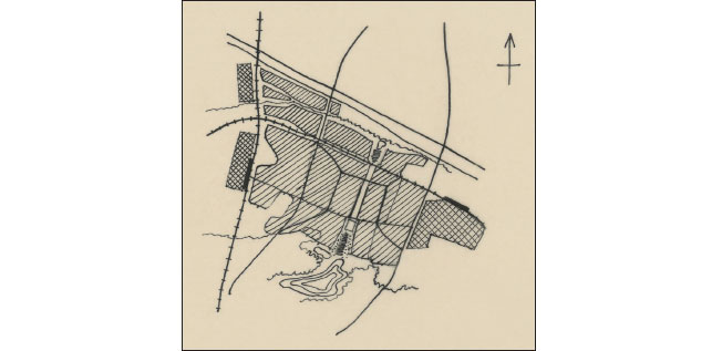
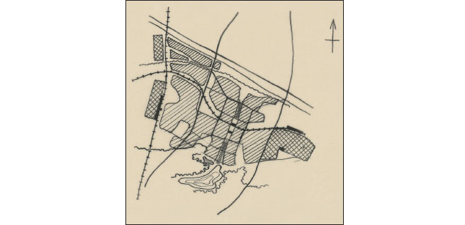
Three teams were asked to contribute their proposals, and ultimately four planning concepts were produced. The general approaches to the compositional concept were of two kinds. The teams led by Teodorowicz-Todorowski and Tadeusz Ptaszycki (the designer of Nowa Huta) proposed concentric, centripetal and quite irregular plans.5 Their advantage was the considerable potential for combining the design with the existing terrain conditions. In both cases the shortcomings became apparent in terms of detailed solutions. The other two planning concepts were based on a cross-shaped layout. They were characterised by axiality, symmetry and considerable geometrisation, which created problems with adaptation to the existing topography (Malisz 1952: 26). The main difference between the cross-shaped solutions was the routing of the railway line. In the design by Stefan Zieliński (of Warsaw’s Miastoprojekt ZOR) the railway ran to the north of the settlement areas and required an embankment of some ten metres in height. According to the concept by Wejchert and Adamczewska (associated with the Warsaw University of Technology), the railway line bent to the south so that it ran, in a deep trench, through the precise centre of the city (Figures 3, 4). The authors of these two concepts had initially worked as one design team, and it was the routing of the railway line that led to their break-up. The cross-town solution, though being in breach of the competition terms, paradoxically turned out to work in its favour (Adamczewska-Wejchert and Wejchert 1995a: I – 39–41). The entries were evaluated by a committee appointed by the Ministry of Urban and Housing Construction. Their overviews are known only from an article by Bolesław Malisz published in the periodical Miasto [The city] in 1952. The concepts of two teams — Ptaszycki’s and Wejchert and Adamczewska’s — were singled out, and according to Malisz, the commission decided that the latter stood out among all the proposals and should be accepted as a starting point for further development. The argumentation for the project to be based on this proposal was that ‘the essence of the task was to properly arrange the urban planning framework of a socialist city’. In addition, despite its shortcomings, this variant offered the potential to ‘achieve a monumental expression of the city’. The commission formulated guidelines for developing the general design, which should incorporate valuable elements from the other concepts (Malisz 1952: 28).
What was this ‘socialist city’ supposed to be like? In the early 1950s, this question was the subject of heated ideological debates. The capitalist legacy of past property relations was criticised. The new approach to these matters, on the other hand, which was reflected by the nationalisation of vast areas of land, made it possible to undertake large design projects and to implement them according to short deadlines (within the scope of economic plans created by the centralised state apparatus). The policy guidelines for urban planning and architecture put a focus on people and their needs. This way, such modern views, which were thriving worldwide at the time, were appropriated for the ideology and propaganda of the young socialist state. Paradoxically, therefore, this pro-social approach was, broadly speaking, universal. As Wejchert himself put it:
The development of planning thought so far indicates that more and more often in projects, discussions at technical councils, and various commissions, a human being becomes the focus of the urban plan. Care for people’s work, recreation, health and cultural development forms the foundation of a city plan. It manifests itself more and more often in the examination of the plan from the point of view of a human being … and not as a geometric drawing expressing the architect’s own preferences. (Wejchert 1954a: 26)
In spite of the imposition of Soviet models, the generation of architects starting their professional careers after the end of World War II relied to a large extent on their experience from the interwar period, and especially on the work of Tadeusz Tołwiński, one of the organisers of the Warsaw University of Technology and author of the textbook Urban Planning (1939). The second volume of this publication discusses, among other things, all the contemporary trends of the time, including Le Corbusier’s ideas on city planning; the concept of the neighbourhood unit; and finally the garden city. The closing section of the book contains the plan of Welwyn, a city based on Ebenezer Howard’s concept. Wejchert was a student of Tołwiński’s, graduating in 1935, and later a doctoral student. During the occupation, he wrote a dissertation about the urban planning of Polish towns (1940–1944), and later, in the new political reality, supplemented it with several dozen urban development plans for towns in the areas which, according to the Potsdam Conference, became part of the country (the so-called Recovered Territories of western and northern Poland). At that time, Wejchert was also associated with the Warsaw University of Technology’s Department of Urban Planning. In 1946, he became head of the Urban Planning Department, and after Tołwiński’s death, as his formal deputy, he took over as head of the faculty in 1951. He also headed Studio 400 of Miastoprojekt Katowice between 1948 and 1950, which dealt with such things as the preparation of a regional planning scheme for Silesia. Hence, when embarking on the design of Tychy, he was very well acquainted with the area, and his approach to spatial design was well established (Wejchert 1947; Adamczewska-Wejchert and Wejchert 1995a: 1–39; Czyżewski and Lipok-Bierwiaczonek 2012: 32–34, 94–97).
Crystallisation of the Socialist City Concept
Beginning in the autumn of 1951, Wejchert and Adamczewska worked on the general plan for the new city of Tychy as part of Warsaw’s Miastoprojekt ZOR. They developed their concept to include solutions from the competing alternatives, drawing on the opinions of the assessment commission and the city design guidelines, which were finally approved in April and May of 1952 (Kuszewski and Niemczyk 1996: 148; AAN, ZOR 1951). The resulting planning scheme was based on two axes intersecting at right angles: the transport axis in the form of a railway line running in a deep trench, and the ‘pedestrian axis’, the southern end of which opened onto Lake Paprocany. Onto this cross-shaped layout the planners set a quadrangle of four inner-city districts, with the central railway station at their junction. In June 1952, the concept of the general plan was presented at a meeting of the Government Presidium attended by Bierut. The design was not accepted, and revisions were recommended to make it more ‘transparent, monumental and socialist in expression’ (Rakoczy 1953).
Wejchert and Adamczewska recalled the value of the mayor’s involvement: ‘Comrade Bierut’s remarks questioning some of the project’s assumptions made it easier for us to work out a new, revised concept, and contributed to our deeper and clearer understanding of the fundamental guidelines for the new city’ (Skulska 1952: 3). The decision that had the greatest impact on further compositional solutions was the change in the routing of the city’s north–south axis. Its southern end was shifted from Lake Paprocany farther west, where the Park of Culture and Leisure was planned in and around the wooded area.
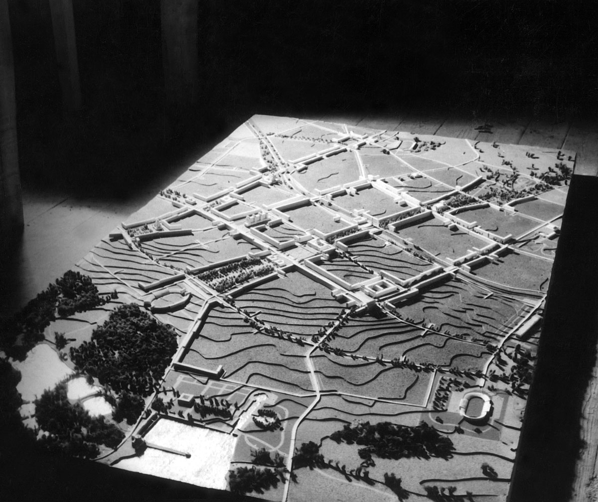
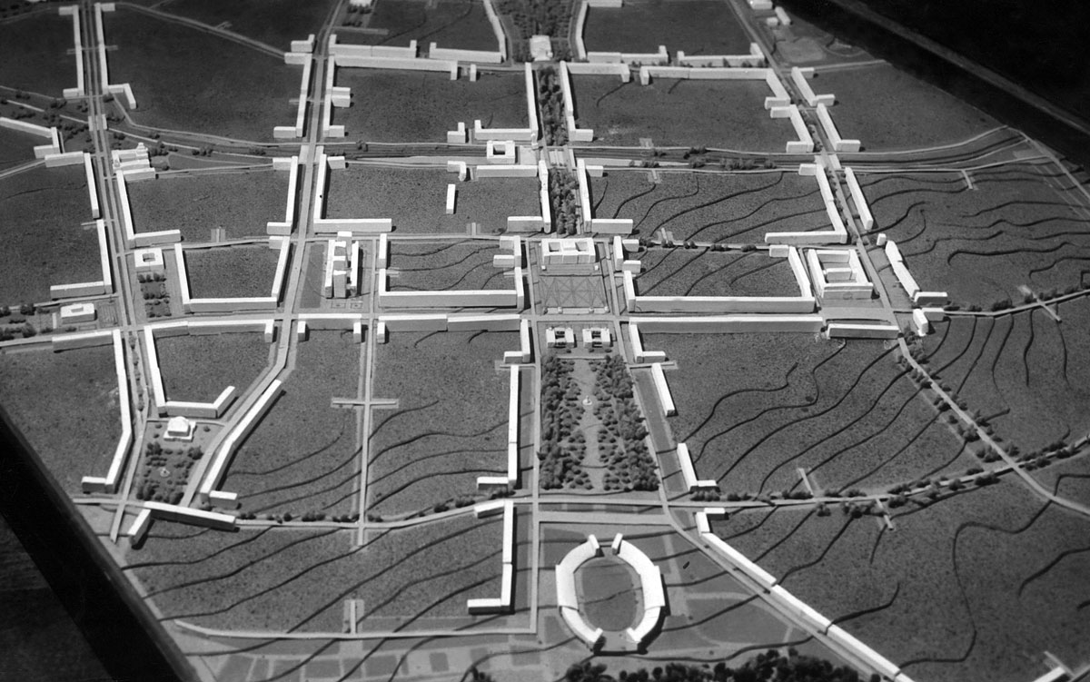
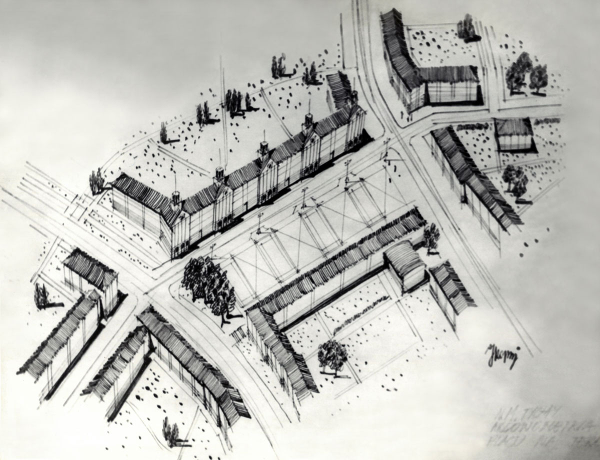
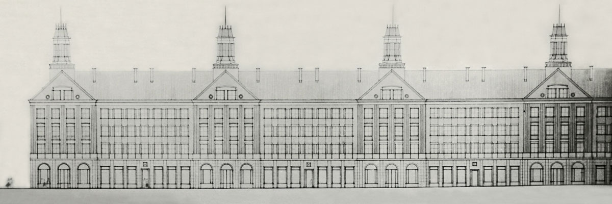
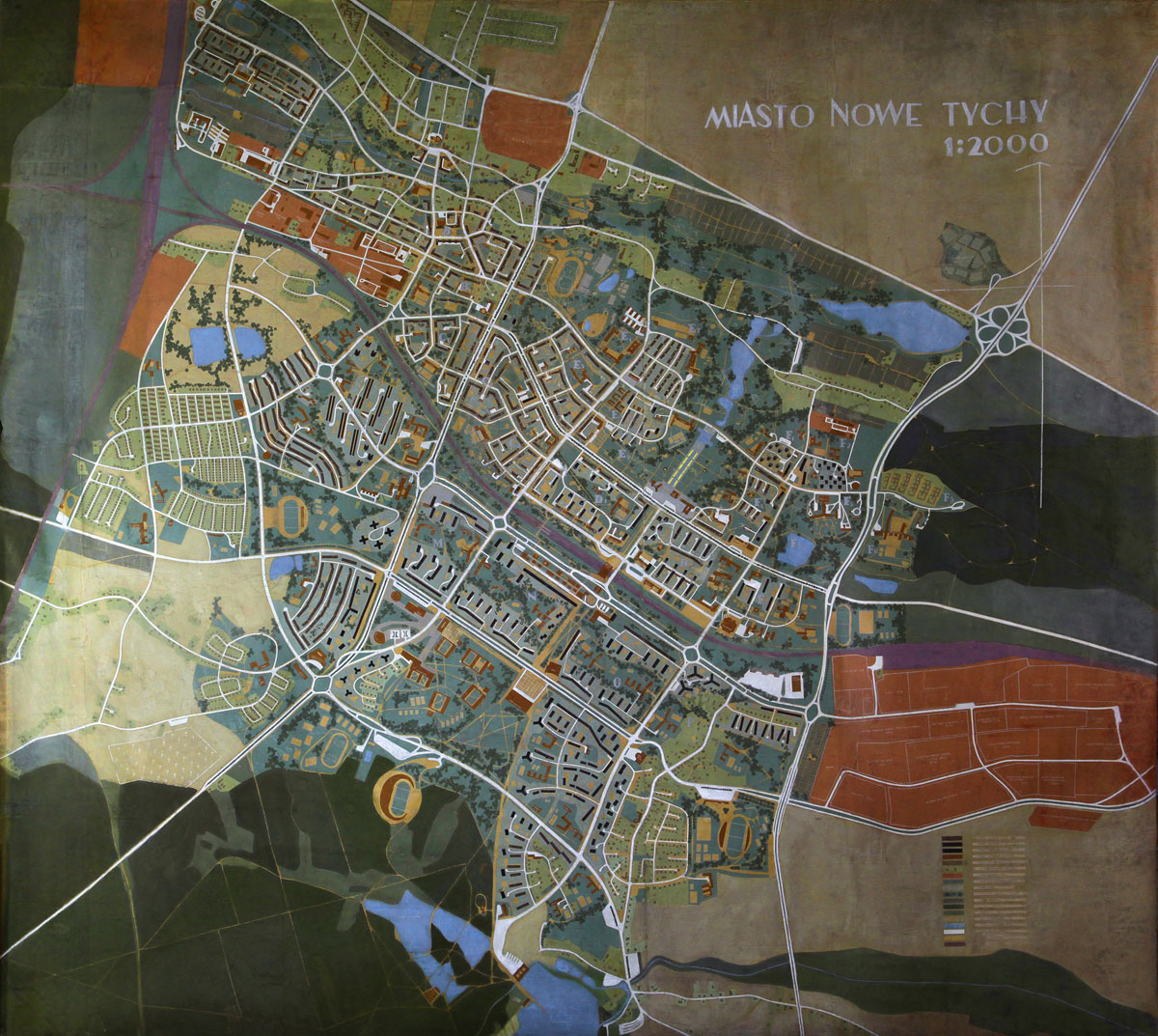
Following revisions, the plan was approved in March 1953 and officially revealed in the Silesian Hall during the First General Architecture Exhibition in Warsaw (Kuszewski and Niemczyk 1996: 148) (Figure 5). The central city zone, and in particular the administrative and cultural centre, was naturally highlighted and appeared to be quite different from the later updates of the plan, in both functional and formal terms. Fully evident here, too, was the socialist realist approach to urban planning and its pursuit of monumentalism on the scale of Warsaw’s MDM and other flagship projects of the Stalinist era, with which the designers would have been familiar via publications of the time, such as those printed in the Miasto magazine. The entire layout features axiality and symmetry, with the dominant urbanist and architectural feature being the central assembly square and the ‘parade axis’, also known as the ‘parade avenue’, i.e., the most prestigious street where intense pedestrian and vehicle traffic was expected. It ran south from the city centre, parallel to the cross-city railway line, roughly paralleling today’s Piłsudskiego Street. The assembly square itself was located on the north-south ‘pedestrian axis’, and was enclosed by monumental architecture. To the east and west, it was to be surrounded by residential frontages, while to the south, twin buildings were planned, one housing the Party Hall and the other one the Trade Union Hall, with the Central Hall of Culture to the north. Terraced steps were to lead up to the latter from the square, forming a natural vantage point. This building, perched on the city’s highest hill, was meant to be the city’s focal architectural feature, dominating the entire surrounding area with its monumental character (Figure 6). Somewhat farther north, at the intersection of the pedestrian axis and the cross-city railway line, the grandiose main railway station was planned, accessible on foot in about 20 minutes from most spots across the city. In the immediate vicinity of the station, the railway trench was planned to be roofed, thus providing traffic continuity along the entire course of the ‘pedestrian axis’. Along and adjacent to it, most of the other citywide and broader functions would be located. Along the axis and just in front of the Culture and Leisure Park would be the city’s main stadium, with a capacity of around 40,000 spectators. Other important buildings were located mainly in the vicinity of the parade avenue, beyond its intersection with the ‘pedestrian axis’. Here, the museum and scientific library buildings as well as the Central Department Store were envisaged, among others. Services were also planned to be grouped in the corners of the inner-city housing estates, along their perimeter streets. The monumental developments along Bielska Avenue, i.e., the section of the Katowice–Bielsko route running westwards from the inner city, were also intended to accommodate services.
Fragment of a mock-up showing the entire new city of Tychy as conceived by Hanna Adamczewska and Kazimierz Wejchert, ca 1952. In the foreground is a fragment of the Culture and Leisure Park, which includes the city’s main stadium. The quadrangle of the city centre is fronted from the south by the central square and the ‘parade axis’ (west–east). In the background, parallel to the parade axis, runs the railway line, which intersects at right angles with the north–south axis, marking the central point of the city centre and the entire city. Photo from the collection of the Tychy City Museum.
As for housing in the newly planned city, an orderly and rigid perimeter development prevailed. In the inner space of the city blocks, the buildings were meant to be arranged more freely. Four-storey houses were intended for the majority of the city, while the main traffic routes were to be accentuated with five-storey buildings. The overall cityscape was planned to rise smoothly towards the centre, with eight-storey residential units as accents in the inner city. The planners also paid close attention to landscaping in an effort to meet the needs of future residents. As far as possible, they sought to break up the monotony and create spatial tensions by making use of broad perspectives and the skilful deployment of architectural accents. The culmination point of the entire scheme was to be the Central Hall of Culture. From the outset, greenery played a very important part in shaping the city. In addition to the pedestrian axis connecting the areas of dense urban development with the Paprocany Forest, there were plans to leave the natural green wedges, where parks and sports and recreation grounds were to be created. Even the trench of the cross-city railway line was supposed to be planted with trees, creating a kind of park to provide additional isolation from the noise of passing trains (AAN, Pracownia XXXI 1952; AAN, Ostrowski 1952; AAN, Olszewski 1952; Rakoczy 1953; Wejchert 1954b). This was the outline of the general plan, which served to develop the staged plan for the construction of the northern part of the city. Based on this, the general plan was prepared and approved on 8 February 1955. It was that plan that became the document to be updated in subsequent decades and that formed the backbone for further more detailed work (Wejchert 1957: 212; Kuszewski and Niemczyk 1996: 151).
Great Construction: Social Realism and Its Rejection
As early as the end of 1950, in parallel with the design of the entire city, intensive work was already underway at the NMT design studio on the concept for Housing Estate A. At first, a ‘comb’ layout of buildings was proposed with free-standing blocks perpendicular to adjacent streets, but the then ZOR president Aleksander Wolski commented that this solution was ‘a hostile manifestation of capitalist mentality’. Consequently, the concept was dropped in February 1951 (Teodorowicz-Todorowski 1956). Follow-up work was immediately undertaken, leading to the creation of a development plan that was approved on 30 March of the same year. Construction began, on a massive scale, as early as April. For logistical reasons, Housing Estate A was located in the vicinity of the village of Tychy and the railway station on the Katowice-Bielsko route, on the outskirts of the future centre. It was a nationalised area, previously owned by the Duke of Pszczyna. The new city’s first housing estate was to provide accommodation for 6,100 people (MMT, Brodziak 1973: 4).
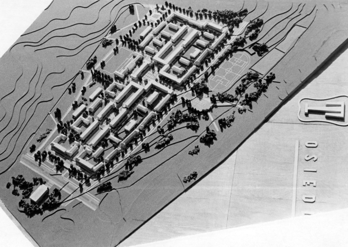
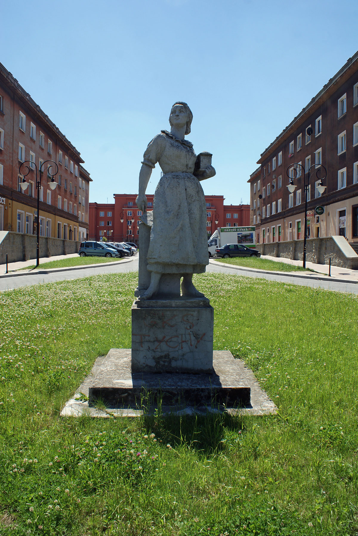
On this occasion, Teodorowicz-Todorowski completely followed the doctrine of socialist realism. He employed a perimeter development, and the overall form of the estate was subordinated to the strict rules of axiality and symmetry (Figure 7). A centre was created in the form of a vast square with a stately community centre as the focal point of the entire housing estate. The area was also meant to serve as the temporary centre of the emerging city, where all official ceremonies would be held. The monumentality of this development was definitely suited to the size of a housing estate rather than an entire city. The neat layout of the buildings may paradoxically be associated with Silesian patronage settlements, such as Nikiszowiec (1908–1919), which were built on the initiative of German industrialists. Similarly to these kinds of housing developments, the question of the self-sufficiency of the settlement was also addressed (Głazek 2005; Chmielewska 2009). The ground floors of houses were designed to accommodate services. The estate also boasted two primary schools, two nursery schools, a crèche, and an outpatient clinic. The buildings were constructed using traditional construction technology, mostly according to routine ZOR designs. In terms of residential buildings, three-storey blocks with slanting tiled roofs prevail. However, the two main axes are emphasised by four-storey buildings with flat roofs and attics. The estate’s space was further complemented by numerous artistic accents in the form of sculptures, bas-reliefs and monumental sgraffito pieces. All the artwork is in the realist style, with themes of the broadly defined construction of socialism. The main north–south axis of the housing estate is marked by a sculpture depicting a female bricklayer — a productivity leader, holding a trowel in her right hand and a model of a residential block in her left. The woman carries it as a gift to the socialist community of the new city (Figure 8). This formal reference to an art theme of the past is another paradox, as the motif stands at odds with the new ideology. The sculpture echoes depictions of St. Hedwig of Silesia carrying a model of a church to the congregation. A church, of course, could not emerge amidst a new socialist estate (Teodorowicz-Todorowski 1956; Kuszewski and Niemczyk 1996: 147; Lipok-Bierwiaczonek 2009).
After Stalin’s death in 1953, the power of socialist ideology began to wane. In 1954 and 1955, socialist realism was gradually becoming a thing of the past, thus losing its importance in promoting the prominence of those in power and manifesting the potency of the socialist state. An opposite trend began to emerge and gain momentum. As early as spring 1954, Estate A was subjected to fierce criticism, with allegations of a lack of space and military barracks-like design, as well as of construction errors and omissions (Kowalski 1954). Teodorowicz-Todorowski refuted these accusations, referring to the norms that were binding at the time when the design was created. The architect also emphasised the disregard for his authorial supervision by the investor and the contractor, accusing the latter of faulty organisation, which he called an ‘unacceptable mess’ (MMT, Teodorowicz-Todorowski 1954). In subsequent months, the criticisms escalated. Dariusz Piątkowski wrote,
Estate A — New Tychy’s first housing estate — is ugly. These are the words of the residents and outside observers alike. The duplicate, monotonous blocks of flats give the impression of large building blocks arranged with mindless uniformity — no finishing touches, no embellishments, no greenery, no flowers. (Piątkowski 1954)
The criticisms sometimes verged on the irrational. Marian Niewiarowski, for instance, held Teodorowicz-Todorowski responsible for the fact that most of the windows of the estate’s blocks faced north. He also questioned its socialist credentials, describing the designer himself as one who ‘failed the hopes contained in the government’s resolution of 4 October 1950’ (Niewiarowski 1956: 2).
As an example of a departure from the humdrum ‘schematism’ of Estate A, Piątkowski juxtaposed it with the much more loosely laid out Estate B (1954). The latter was designed in 1953 by Wejchert and Adamczewska, members of Warsaw’s Miastoprojekt ZOR. Just 12 months earlier, this concept had been heavily criticised for breaking with symmetry and axiality. The evaluating commissions recommended developing a variant with a more rigid ‘realist’ layout, which Adamczewska and Wejchert managed to avoid (Wejchert 1955). In 1954, however, the subject was viewed differently (Piątkowski 1954; Niewiarowski 1956).
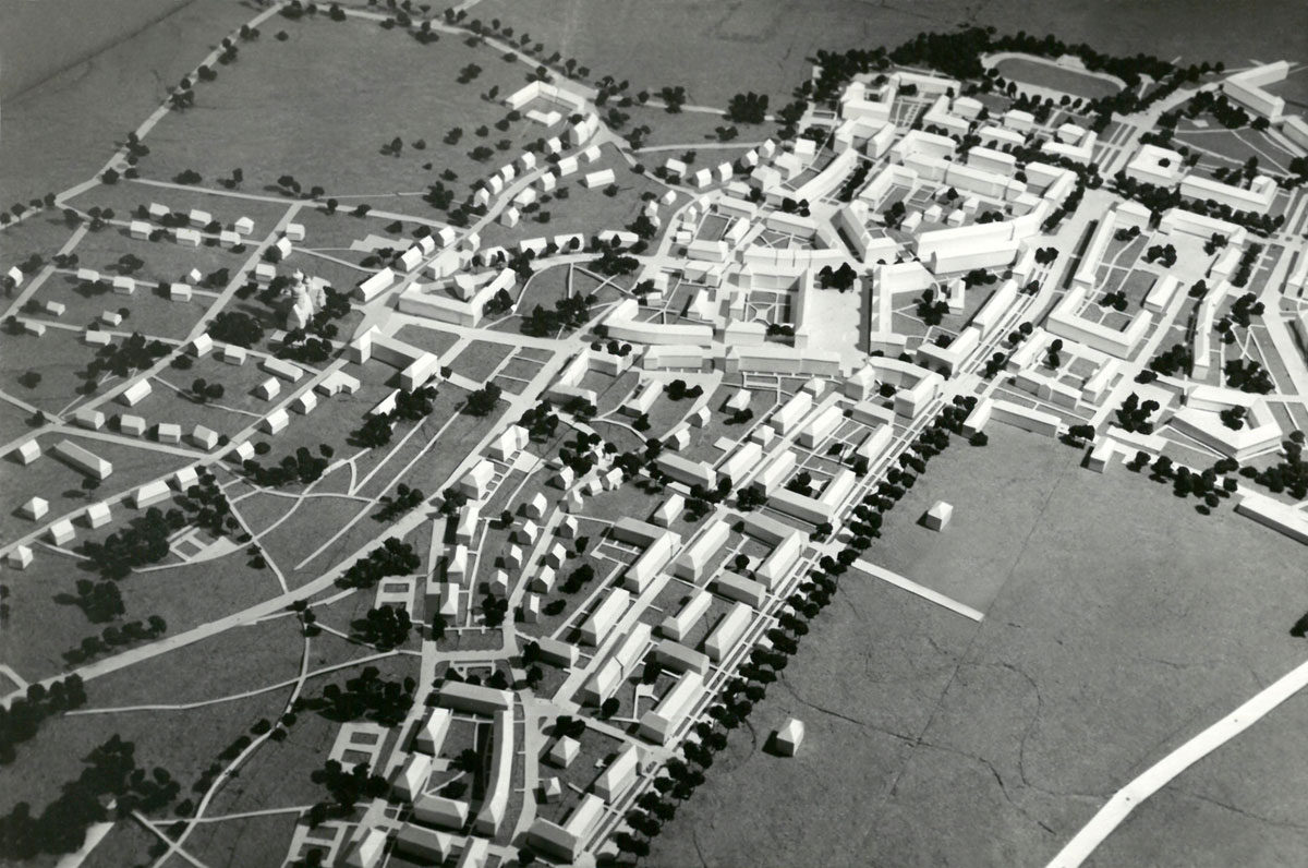
The housing estate’s construction also began before the city’s general planning scheme was approved. It was intended to provide accommodation for 14,500 residents and be another step towards a grandiose socialist realist inner city. Due to its location in the immediate vicinity of the buildings of the former village of Tychy, the estate was designed to match them seamlessly (Figure 9). Consequently, Adamczewska and Wejchert kept the demolition of existing buildings to a minimum.
There is still some perimeter development in Housing Estate B, but the complex as a whole breaks away from axiality and symmetry almost completely. To a large extent, the layout of the buildings is more casual, adapted to the shape of the terrain, smoothly blending in with the older detached and farm buildings with their accompanying greenery, and subordinating to some of the former traffic routes, such as the road towards the village of Paprocany. Such routes featured 19th-century stone roadside crosses, marking rural religious sites important for the local communities by which they commemorated notable events, expressed gratitude for graces received, or confirmed the religious commitment of particular people. A cross dating from 1858 has been preserved in Biblioteczna Street. However, it is not the only element of the local religious heritage. The ancient parish church of St. Mary Magdalene was given a direct link to the new city. Remarkably, this church served not only the former rural population but also the residents of the newly erected housing estates. From the authorities’ perspective, building a church for the local community was out of the question. Nevertheless, the 1951 city plan by Adamczewska and Wejchert included a location for this purpose, defined as a ‘cultural service facility’. Erecting a new church did not become a feasible option until after the 1956 political thaw. It was at this time that several competitions were called for the design of religious facilities in Poland, including Nowa Huta and Tychy, yet the successful entries were not actually built due to another downturn in the political climate (Adamczewska-Wejchert and Wejchert 1995b: IX–21).
For the greater part of the 1950s, therefore, the only opportunity to engage in Christian rituals available to the new city’s community was at the Church of St. Mary Magdalene. It is situated on a small hill, a location that naturally contributes to its important ideological and spatial identity. Between the church and the buildings of Housing Estate B, the city planners decided to create a kind of ‘interface’, connecting the old and the new. They designed an open public space in the form of a small town square enclosed from the east and west by residential frontages. To the north, the main focus of the layout was the old church, while to the south, the space was completed with the theatre building. Although this planning layout did not fully take shape until the early 1960s, the design had already been conceived in 1953. It was precisely within this space that the new city opened up onto the rural sacred zone and broke away from the spatial and ideological framework of socialist realism.
As far as the designers were concerned, an extremely important inspiration, or perhaps the key one, came from exploring small town planning solutions across Poland, which, as previously mentioned, Wejchert had done as part of his doctoral studies. He also pursued urban planning projects on this scale in the early post-war years, when he catalogued historic buildings and prepared simplified planning concepts for towns located in the Recovered Territories (Wejchert 1947). To a large extent, his previous experience can be seen in the shape of Housing Estate B. Three-storey buildings prevail here, with four-storey blocks found in some parts. The buildings were constructed using traditional technology, with plaster-clad elevations and slanting, tiled roofs. Despite the intimate, historicist forms, however, there are no references to local tradition here — the original fabric of the old town of Tychy was made up of red-brick family buildings and the few timber houses that had survived. Estate B also includes a second, far more impressive square, which acts as yet another surrogate city centre (Figures 10, 11). The designers created a traditional town square space with no inclination towards monumentality. Instead, the buildings have been customised with high skylights, which highlights the importance of this part of the city. The square itself was named after Bierut, to pay homage to the president for his personal involvement in drawing up and approving the city plan. From the mid-1950s onwards, the idea of commemorating the patron with a monument would also recur, though never came to fruition (MMT, Plac Bieruta). Unlike Housing Estate A, no other ornamental accents with ideological overtones were introduced. However, the design included a comprehensive range of services, including shops, coffeehouses, cafés, restaurants, crèches, nurseries and schools. Construction of the entire estate went on until 1959, with the addition of public venues extending well into the next decade. Consequently, the estate features some late modernist architecture (Adamczewska 1955: 10–11; Wejchert 1960; Kuszewski and Niemczyk 1996: 149–150).
Towards Modernism
Socialist realism within Tychy took hold in both the design and construction spheres. The city was supposed to be built in stages: from the outskirts towards the city centre, and then farther south, to the edge of the woods and Lake Paprocany. Only the first two settlements, Housing Estates A and B, were completed while the doctrine was still in force. According to the staged plans, the socialist realist administrative and cultural centre in the southern part of the city was not to come into existence until after 1961.6 It was here that concepts akin to ‘international’ socialist realism, featuring monumentalist concepts, were to emerge. These plans did not go beyond the stage of initial design sketches, which raises the question whether this provisionality was not to some extent intentional, or at least convenient, from Adamczewska and Wejchert’s perspective. Such questions are triggered by their previous experience of designing smaller urban settings. The solutions applied in Housing Estate B also provide food for thought, as this settlement was connected with the solely legitimate doctrine primarily by a peculiar affinity to tradition and the atmosphere of towns with historicist architecture. In shaping the space of that housing estate, the designers consciously made use of an ideological element that was completely at odds with socialist realism, the Church of St. Mary Magdalene. The use of this church seems particularly striking when juxtaposed with the opposite trend, as exemplified by the then-current plans to conceal the Church of the Assumption of the Blessed Virgin Mary in Łódź or the Church of the Holiest Saviour in Warsaw behind new developments. Perhaps deviating from the monumental concept of the city centre would not have been a major problem for Wejchert and Adamczewska. In view of the widespread critique of socialist realism, they effectively distanced themselves from the strictly doctrinaire concepts.
Consequently, the only purely socialist-realist concept carried out in Tychy is Teodorowicz-Todorowski’s Housing Estate A, yet its intimate form is quite distant from such monumental urban schemes as Warsaw’s MDM. Estate A may be associated with the working-class housing estate of the early twentieth century, though it represents a completely different approach. While patronage estates were built in the vicinity of industrial plants, the housing units of the new city are the result of the deglomeration process. The common and overriding idea in both cases is that of improving the living conditions of workers by building low-cost housing with extensive social amenities, which goes hand in hand with modernisation processes. Such traditions were well established in Upper Silesia, as exemplified by the block housing project of Nikiszowiec (1908–1919) and the garden city–inspired Giszowiec (1907–1910). However, this tradition was unwelcome as it was conceived in the capitalist system. In the post-war reality, the trend towards siting housing developments by the ‘factory fence’ was officially rejected (Tworkowski and Malicki 1952: 249). Adamczewska and Wejchert’s designs, however, hark back to the legacy of Tadeusz Tołwiński, the founder of the Polish school of urban planning, who was, on the one hand, an expert on old architecture and an active member of the Society for the Preservation of Monuments of the Past and, on the other, a promoter of the idea of the garden city and designer of the settlements of Ząbki (1912) and Podkowa Leśna (1916) (Kotaszewicz 2016). In his concepts, Tołwiński advocated using buildings of up to three or four storeys and providing good air circulation and ‘letting sunlight into the living areas and surrounding them with greenery’ (Tołwiński 1939: 338). However, while Tołwiński’s projects of this type were in keeping with the vernacular trend, Wejchert and Adamczewska, in the post-war realities, were mostly forced to use standard ZOR housing designs. These made rather arbitrary references to historical forms, but offered the potential to shape integrated urban spaces. Nonetheless, the residential buildings of Estate B still show a fair amount of individuality (Adamczewska 1950; Czapelski 2016). This is already different in the case of the subsequent housing compounds, which became increasingly more uniform as a result of the prefabrication system, imposed by the state, that had been in operation since the mid-1950s. Notwithstanding these constraints, Wejchert and Adamczewska invariably tried to design resident-friendly spaces. Housing Estates C and E are a continuation of the compositional arrangements used in Housing Estate B, but without the links to the original buildings — the city’s development at that time covered largely agricultural areas, so former transportation routes were partly taken into consideration.
In the late 1950s, buildings representing late modernism began to appear in Tychy as an expression of a broad trend that became clearly apparent in the Eastern Bloc countries after the political events of 1956. The first venues built in this style were intended for public use, but with priority being given to housing, their construction was considerably delayed. In 1961, the Andromeda cinema opened in Housing Estate B, and in 1965 the Mały theatre. In the early 1960s, Bierut Square and the Old Town Square were further enhanced with arcaded buildings. Although their origin dates to small towns of the past, the form was modernised to be clear and geometric, with horizontal divisions corresponding to the slender columns. By the end of the 1950s, the first single-staircase high-rises also appeared in the city. This natural tendency of the time may also be perceived as a continuation of Tołwiński’s ideas. In Urban Planning, he expressed his appreciation for the ‘excellent architectural effects’ achieved with this type of building, as well as the capacity to accommodate a large number of people while maintaining extensive open areas. However, he also saw the downsides, including the cost of construction and maintenance involved, and difficulties with vertical transport; he therefore anticipated that the use of high-rise blocks would be limited to exceptional circumstances (1939: 318). The technological developments of the 1950s, however, made the use of this type of development more feasible. In Estates C and E, high-rise blocks appear as single accents among the four- and five-storey buildings. Their number began to increase considerably towards the end of the 1960s, but even then the relatively high level of architectural solutions applied in Tychy is evident, especially in comparison with many monotonous developments in other Polish cities, such as in the Upper Silesian town of Jastrzębie Zdrój.
In ideological terms, Tychy’s socialist realism proved to be very superficial and faded rather quickly. However, its functional features have stood the test of time. The residents today appreciate the cosy spaces within relatively low-rise buildings and the historicist forms and details. The abundance of recreational greens is much appreciated too. The overall concept of the city has also turned out to be sustainable and accommodating. Its axial and symmetrical layout became a versatile basis for the large-scale adoption of modernist concepts in the following decades (Figure 12). The key role in this was played by the Municipal Building Design Company Miastoprojekt Nowe Tychy, established on 1 July 1955 (Brodziak et al. 1975: 10–11). After the political thaw of 1956, the office was largely staffed by young graduates of the Wrocław and Kraków Technical Universities, for whom socialist realism was merely a chapter in their university studies, and who already fully embraced late modernism in their professional careers. Under the leadership of the chief designers, the city took shape through the consistent work of Maria Czyżewska and Andrzej Czyżewski, Marek Dziekoński and Ewa Dziekońska, Bożena Włodarczyk and Janusz Włodarczyk, Wacław Jaciow, Emilian Piasecki and many others, until the political breakthrough of 1989. International relations were important in this context as well, and those were by no means limited to the Eastern Bloc countries. Wejchert and Adamczewska, who were both researchers and teachers at the Warsaw University of Technology, were particularly active in this regard.
The basic compositional components of the city have proven sustainable, irrespective of the political doctrines and contexts. In the course of the great construction, the north–south pedestrian axis remained a recreational area, which became widely known as the green axis. The east–west axis maintained its transport function as the railway trench indeed came to fruition. At the dawn of the 1960s, work began on new concepts for the city centre, which then began to be referred to as a retail and service hub. It was eventually sited somewhat to the north of the original plan, just over the railway line trench. However, this concept did not see implementation either. As for the space where the central assembly area was supposed to be built, it ended up within the green axis and the adjacent housing estates, while the ‘parade avenue’ simply evolved into one of the city’s main thoroughfares (now Piłsudskiego Avenue).
Notes
- Hanna Adamczewska, a graduate in 1946 of the Faculty of Architecture at the Warsaw University of Technology, collaborated with Wejchert. From 1962, she was known as Hanna Adamczewska-Wejchert. [^]
- The authors worked in the design office led by Adamczewska and Wejchert. They belong to a generation of architects with a critical view of modernism. [^]
- In 1934, Tychy was granted the status of a municipality, but when the war ended the original village status was restored. Following the resolution of the Government Presidium, the president of the Council of Ministers issued an ordinance on 8 November 1950 granting Tychy the status of a city on 1 January 1951. The current districts of Paprocany and Wilkowyje lost their administrative status as communes and were incorporated into the newly formed city. The population was then estimated at 11,100 (PRM 1950: 706; AAN, 2/331/0/4.1/1880, ZOR ZG. 1950: 1). [^]
- Concepts 3 and 4 drew on the German plans (Kuszewski and Niemczyk 1996: 139–140; AAN, 2/331/0/4.1/1880, ZOR ZG 1951: 2). [^]
- Teodorowicz-Todorowski was only allowed to propose another design if its premises were different from the previous one. [^]
- The multi-stage plan for the city’s construction for the years 1956 to 1960 provided for the full completion of the northern part of the city bounded from the south by the cross-city railway line, the west–east axis (MMT, Miastoprojekt [1955]). [^]
Competing Interests
The author has no competing interests to declare.
References
Unpublished Sources
AAN. Archiwum Akt Nowych w Warszawie, 2/331/0/4.1/1880.
AAN. Ministerstwo Budownictwa Miast i Osiedli [Benko, Marian, Karnas W., and Romuald Pieńkowski]. 1951. Koreferat w sprawie ekonomiczno-technicznych założeń projektowych miasta Tychy, 3.03.1951: 1–7.
AAN. Olszewski, Eugeniusz. 1952. Uwagi na temat zagadnień komunikacyjnych w mieście Nowe Tychy, Warszawa, 29.04.1952.
AAN. Ostrowski, Wacław. 1952. Koreferat do projektu wstępnego miasta Nowe Tychy (Konspekt), 25.04.1952.
AAN. Pracownia XXXI Miastoprojekt ZOR. 1952. Opis wstępnego planu zagospodarowania nowego miasta Tychy: 1–18.
AAN. ZOR. 1951. Skrót założeń projektowych m. Tychy [uzupełniające opracowanie założeń projektu m. Tychy przedstawione na posiedzeniu KOPI dn. 2.10.1951]: 1–6.
AAN. ZOR ZG. 1950. Uzupełnienie Rozdziału III założeń projektowych dla m. Tychy [materiały do konferencji w sprawie Tych w dniu 16 stycznia 1951 r.]: 1–21.
MMT. Muzeum Miejskie w Tychach.
MMT. Brodziak, Tadeusz. 1973. Budownictwo mieszkaniowe w Tychach. Tychy 1973.
MMT. Miastoprojekt ZOR Warszawa. [1955]. Nowe miasto Tychy — północ. Plan etapowy 1956–1960. Skala 1:2000.
MMT. Plac Bieruta i otoczenie. Prace porządkowe do wykonania i realizacji [Bierut Square and surroundings. Landscaping work to be undertaken].
MMT. Teodorowicz-Todorowski, Tadeusz. 1951. Opis techniczny do ‘Projektu wstępnego planu ogólnego NMT’. Gliwice.
MMT. Teodorowicz-Todorowski, Tadeusz. 1954.
Published Sources
Adamczewska, H. 1950. Cechy narodowe polskiego miasteczka. Architektura, 3–4.
Adamczewska, H. 1955. Pierwszy etap pracy nowotyskiego warsztatu projektowego. Miasto, 2(52): 8–14.
Adamczewska, H. 1964. Wpływ realizacji na przemiany planu miasta. Warszawa: Arkady.
Adamczewska-Wejchert, H. 1965. Miastoprojekt Nowe Tychy 1955–1965. Katowice-Tychy: Miastoprojekt Nowe Tychy.
Adamczewska-Wejchert, H, and Wejchert, K. 1995a. Jak powstawało miasto. Monografia planowania cz. 1. Tychy: Pergamon.
Adamczewska-Wejchert, H, and Wejchert, K. 1995b. Jak powstawało miasto. Monografia planowania cz. 2. Tychy: Pergamon.
Adamczewska-Wejchert, H, and Zadrożna, R. [1985]. Tychy w architekturze XXX-lecia. Tychy: Towarzystwo Przyjaciół Ziemi Tyskiej.
Åman, A. 1992. Architecture and Ideology in Eastern Europe during the Stalin Era. An Aspect of Cold War History. Cambridge: The MIT Press.
Basista, A. 2001. Betonowe dziedzictwo. Architektura w Polsce czasów komunizmu. Warszawa-Kraków: Wydawnictwo Naukowe PWN.
Benko, M. 1953. Aktualne problemy urbanistyki węgierskiej. Miasto, 4(30): 9–19.
Bielecki, C, Jałowiecki, B, Lubiatowski, A, Parandowski, Z, Szczepanik-Dzikowski, J, and Jasturn, T. 1990. Paskudne miasto. Rozmowa architektów. Res Publica, 3(30): 14–24.
Bierut, Bolesław. 1949. Sześcioletni plan odbudowy Warszawy. Warszawa: Książka i Wiedza.
Brodziak, T, Kowal, E, and Sokołowska, L. 1975. 20 lat Miastoprojektu Nowe Tychy. Ed. by M Wojciechowska. Tychy: Miastoprojekt Nowe Tychy.
Chmielewska, M. 2009. Osiedla i kolonie robotnicze w Katowicach — identyfikacja, rozmieszczenie i stan zachowania. Acta Geographica Silesiana, 6: 9–14.
Cymer, A. 2020. Architektura w Polsce 1945–1989. Warszawa: Centrum Architektury.
Czapelski, M. 2016. Między projektem doskonałym a koniecznością ekonomiczną. Dyskusje polskich architektów o projektach typowych 1953–1956. Rocznik Historii Sztuki, 41: 197–206.
Czyżewski, A, and Lipok-Bierwiaczonek, M. 2012. Profesor Kazimierz Wejchert w stulecie urodzin. Tychy: Muzeum Miejskie w Tychach.
Dawidowicz, WG. 1951. Planowanie miast. Podstawy gospodarcze i techniczne. Warszawa: Państwowe przedsiębiorstwo Fotogrametrii i Kartografii.
Głazek, D. 2005. Gdzie mieszkał ongiś robotnik? In. Historyczne osiedla robotnicze. Referaty wygłoszone na sesji naukowej w Katowicach w dniach 9–10 września 2005, 8–16. Edited by Bożek G. Katowice: Śląskie Centrum Dziedzictwa Kulturowego w Katowicach.
Goldzamt, E. 1956. Architektura zespołów śródmiejskich i problemy dziedzictwa. Warszawa: Państwowe Wydawnictwo Naukowe.
Gzell, S. 2000. Modernizm a planowanie miast po II wojnie światowej: Nowe Tychy jako przykład. Kwartalnik Architektury i Urbanistyki, 45(2): 149–155.
Gzell, S. 2013. Urbanistyka modernistyczna po cezurze II wojny światowej — przykłady Warszawy i Nowych Tych. In Wpływ dorobku II Rzeczpospolitej na urbanistykę i architekturę powojenną, 33–44. Edited by Witold Czarnecki. Białystok: Wyższa Szkoła Finansów i Zarządzania w Białymstoku.
Eckhardt, P. 2016. Przestrzeń i architektura jako obraz doktryny politycznej. Przykład państw socjalistycznych. Miscellanea Historico-Iuridica, 15(2): 11–20. DOI: http://doi.org/10.15290/mhi.2016.15.02.02
Jankowski, S. 1956. Pamiętam 4 lipca 1947 roku. Świat, 13.
Jász, B. 2018. Hidden Modernism: Architecture Theory of the Socialist Realist G. Periodica Polytechnica Architecture, 49(1): 92–97. DOI: http://doi.org/10.3311/PPar.12168
Kotarbiński, A. 1952. Realizm socjalistyczny w architekturze. Warszawa: Spółdzielnia Wydawniczo-Oświatowa ‘Czytelnik’.
Kotaszewicz, T. 2016. Tadeusz Tołwiński 1887–1951. Architekt. Urbanista. Twórca Polskiej Szkoły Urbanistyki. Warszawa: Oficyna Wydawnicza Politechniki Warszawskiej.
Kowalski, J. 1954. Brakoróbstwo rodzi się także przy rysownicy. Trybuna Robotnicza, 1 June.
Królikowski, J. 2020. Poetyka miasta socjalistycznego. Warszawa: Oficyna Wydawnicza ‘Rewasz’.
Kuszewski, M, and Niemczyk, S. 1996. Przestrzeń urbanistyczno-architektoniczna. In: Tychy 1939–1993. Monografia miasta, 139–165. Edited by Marek S. Szczepański. Tychy: Zarząd oraz Rada Gminy Tychy.
Lewczenko, JP. 1949. Planowanie miast. Wskaźniki techniczno-ekonomiczne. Warszawa: Państwowe Wydawnictwa Techniczne.
Lipok-Bierwiaczonek, M. 2009. A jak Anna. Wczoraj i dziś pierwszego osiedla ‘Nowych Tychów’. Tychy: Muzeum Miejskie w Tychach.
Malisz, B. 1952. Nowe miasto Tychy. Krytyczne omówienie wstępnych prac urbanistycznych. Miasto, 1(15): 24–28.
Niewiarowski, M. 1956. Zejdźmy na ziemię! Dziennik Zachodni, 27–28 May.
Péteri, G. 2004. Nylon Curtain — Transnational and Transsystemic Tendencies in the Cultural Life of State-Socialist Russia and East-Central Europe. Slavonica, 10(2): 113–123. DOI: http://doi.org/10.1179/sla.2004.10.2.113
Piątkowski, D. 1954. Na ZOR-owskim szlaku. Abecadło Nowych Tych. Budowniczy Nowych Tych, 17 December.
Pieńkowski, R. 1952. Nowe miasta na obszarze niecki węglowej. Miasto, 1(15): 21–24.
Prezydium Rządu. 1950. Uchwała Prezydium Rządu z dnia 4 października 1950 r. w sprawie rozbudowy m. Tychy. Monitor Polski 109, item 1372, pp. 882–883. Available online at http://isap.sejm.gov.pl/isap.nsf/DocDetails.xsp?id=WMP19501091372 (accessed on 12 July 2021).
Prezes Rady Ministrów. 1950. Rozporządzenie prezesa Rady Ministrów z dn. 8 listopada 1950 r. Dziennik Ustaw Nr 51. Poz. 472. Available online at http://isap.sejm.gov.pl/isap.nsf/DocDetails.xsp?id=WDU19500510472 (accessed on 12 July 2021).
Rada Ministrów. 1951. Uchwała Nr 205 Rady Ministrów z dnia 17 marca 1951 r. w sprawie utworzenia dzielnicy Nowa Huta w m. Krakowie. Available online at http://isap.sejm.gov.pl/isap.nsf/DocDetails.xsp?id=WMP19510430544 (accessed on 13 July 2021).
Rakoczy, J. 1953. Nowe Tychy — miasto przyszłości. Dziennik Zachodni, 15 July.
Skalimowski, A. 2021. Edmund Goldzamt (1921–1990). Refleksyjny dogmatyk. Kwartalnik historii nauki i techniki, 66(4): 171–189. DOI: http://doi.org/10.4467/0023589XKHNT.21.033.14797
Skulska, W. 1952. Od starych do nowych Tych. Trybuna Ludu, 28 October.
Strakoš, M. 2010. Nová Ostrava a její satelity. Kapitoly z dějin architektury 30.–50. let 20. století. Ostrava: Národní památkový ústav v Ostravě.
Szczepański, MS. 1991. ‘Miasto socjalistyczne’ i świat społeczny jego mieszkańców. Warszawa: Uniwersytet Warszawski.
Teodorowicz-Todorowski, T. 1956. Przede wszystkim prawda. Dziennik Zachodni, 29–30(July): 2.
Teodorowicz-Todorowski, T. 1987. Moje kalendarium życia, działalności i pasji, Gliwice: Politechnika Śląska.
Toeplitz, KL. 1953. ‘Brygady szturmowe’ budują miasta. Miasto, 4(30): 1–5.
Tołwiński, T. 1939. Urbanistyka. T. 2. Budowa miasta współczesnego, Warszawa: Wydawnictwo Zakładu Urbanistyki Politechniki Warszawskiej.
Tworkowski, S, and Malicki, Z. 1952. O architekturze osiedli ZOR. Architektura, 10: 249–256.
Udovički-Selb, D. 2009. Between Modernism and Socialist Realism: Soviet Architectural Culture under Stalin’s Revolution from Above, 1928–1938. Journal of the Society of Architectural Historians, 68(4): 467–495, http://www.jstor.org/stable/10.1525/jsah.2009.68.4.467. DOI: http://doi.org/10.1525/jsah.2009.68.4.467
Wejchert, K. 1947. Miasteczka polskie jako zagadnienie urbanistyczne. Warszawa: Wydawnictwo Ministerstwa Odbudowy.
Wejchert, K. 1954a. O niektórych zagadnieniach projektowania nowego miasta. Miasto, 5(43): 24–28.
Wejchert, K. 1954b. Nowe Tychy — miasto górników i hutników — wielkich alei, parków i gmachów. Budowniczy Nowych Tych, 12 April.
Wejchert, K. 1955. Kraina ZOR. Urbanistyka na warsztacie. Budowniczy Nowych Tych, 1 January.
Wejchert, K. 1957. Nowe w Nowych Tychach. Architektura, 6: 211–223.
Wejchert, K. 1960. Nowe Tychy. Tychy: Arkady.
Wejchert, K. 1969. Miasto na warsztacie. Warszawa: Arkady.
Węcki, M. 2011. II wojna światowa. In: Tychy. Monografia historyczna. Edited by Ryszard Kaczmarek. Tychy: Miasto Tychy: 213–245.
Włodarczyk, W. 1991. Socrealizm. Sztuka polska w latach 1950–1954. Kraków: Wydawnictwo Literackie.
Wróblewski, S. 2013. Odbudowa zespołów staromiejskich — wybrane zagadnienia dotyczące współczesnych realizacji w Polsce. In: Zeszyty Naukowe Państwowej Wyższej Szkoły Zawodowej im. Witelona w Legnicy 9: 89–104.
Zieliński, J. 2009. Realizm socjalistyczny w Warszawie. Urbanistyka i architektura (1949–1956). Warszawa: Fundacja Hereditas.
