Introduction
Burgundian court life was essentially nomadic in nature, as were most other late mediaeval and early modern courts, from France to the Holy Roman Empire. The eponymous ‘Prince’s Court’ at Bruges (Figure 1) was part of an extensive network of residences that provided accommodation for the travelling household of the ducal court. Originally centred upon Paris and Burgundy, the network slowly shifted towards the county of Flanders from the late 14th century onwards, as one of the consequences of Philip the Bold’s marriage to the heiress of Flanders, Margaret of Male. During the 15th century, keeping pace with Philip the Good’s expansion of Burgundian dominion in the Low Countries, other centres of gravity were added to the Flemish ones. Brussels, in the duchy of Brabant, eventually became the most important in terms of frequency and length of use.1 Nevertheless, the Bruges palace, ‘Burgundian’ since the time of Philip the Good’s grandfather’s, remained highly important. The significance of the Prince’s Court is emphasized by several key events that took place there, including the marriage of Isabella of Portugal and Philip the Good in 1429 and the foundation of the order of the Golden Fleece in 1430. It was also the scene of the marriage of Margaret of York and Charles the Bold in 1468, after which the residence lost its importance until the property was sold by Philip II of Spain in 1576.2
Reconstruction of the Prince’s Court at Bruges. Image created by Sanne Maekelberg.
Due to several centuries of parcelling and successive renovations, this once substantial residence can no longer be studied in situ. This essay presents a reconstruction of the Prince’s Court as shaped by the renovations which started in 1445 and ended in 1468, when it was at its peak. The various phases of this process, as well as the spatial organization of the residence, are described here on the basis of the surviving construction accounts.3 This method was pioneered over twenty years ago for the ducal palace on the Coudenberg in Brussels (Brabant), but without the benefit of archaeology and of digital tools.4 Partial excavations accomplished by the archaeologists of the city of Bruges (2004), as well as our own examination of the site (2013–2014), have allowed us to locate the Prince’s Court with greater precision than before on the site, which is now entirely built over (Hillewaert et al. 2007; Maekelberg 2014). For the purpose of this study, we will focus primarily on the main building containing the ducal apartment and great hall. We use computer-aided design (CAD) software to analyse the different hypotheses for the spatial organization of the residence, and provide a more accurate reconstruction of the court complex (Martens 2015; Hoppe 2015). Given that CAD is a site-based approach based on true dimensions, the fudging of measure or scale is not possible.5 This not only leads to the exact location of the residence on the actual site, but also allows different hypotheses to be tested against a real environment, thus leading to more precise decision-making. The results of this process are not only classic plans and section renderings, but also a complete 3D model, which makes the information more accessible to the uninformed observer.
Visualizing Late Mediaeval Bruges
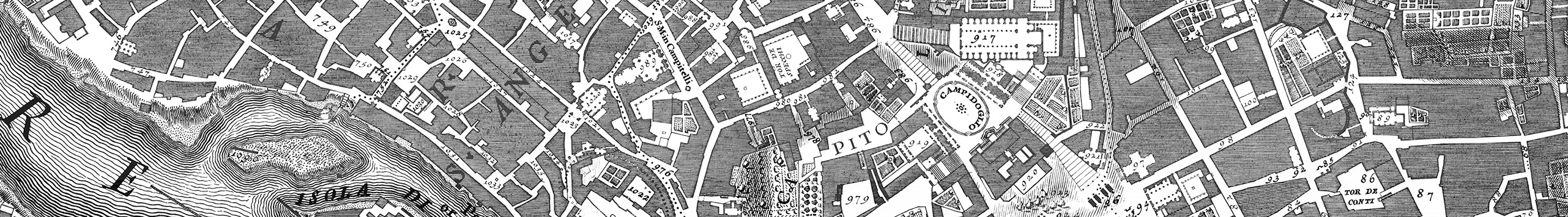
One of the main problems the architectural historian of the late mediaeval Burgundian court has to deal with is the scarcity of contemporary iconographical sources. Bruges is no exception, although the available sources are more useful than most.6 Before the confirmation of the site from the excavation campaign of 2004, the Prince’s Court could only be situated on the basis of two sources: Marcus Gerards’ 1562 map of Bruges and the engraving made for the Flandria Illustrata by Antonius Sanderus of 1641 (Figures 2 and 3; see also the animated reconstruction, ‘The Prince’s Court at Bruges’, 2018). Each has its own idiosyncrasies.
Marcus Gerards, City View of Bruges, 1562 (Gerards 1562).
Unknown draughtsman, ‘Palatium Principes in Urbe Brugensi’, from Antonius Sanderus’ Flandria Illustrata (1641–1644).
The Prince’s Court at Bruges: A Reconstruction of the Lost Residence of the Dukes of Burgundy, 2018. Based on A. Sanderus, Flandria Illustrata. Coloniae (Amsterdam): Blaeu, 1641–1644. Maps by geopunt Vlaanderen & Google. Excavation plan by Raakvlak Brugge. Reconstruction by Sanne Maekelberg, KU Leuven.
Gerards’ bird’s-eye view shows that the Prince’s Court occupied an entire block, a short walk from the main marketplace.7 The main entrance was located in the Noordzandstraete on the southeast side of the block, represented at the bottom of Gerards’ view. On the northeast side (at right in Gerards’ view), remnants of 16th- and 17th-century masonry can still be seen at the boundary with the Mint complex (Munthof) and the Gheerwijnstraete, such as the Mint gate with its 16th-century vault opening up towards the Noordzandstrate. There was a secondary entrance from the Moerstraete to the northwest, in the background of the view, next to the Hôtel Vert on the north corner of the block, which was also part of the Prince’s Court. This was a more reclusive residence for the duke, away from busy court life; after a few years it became the bachelor’s residence of his heir, Charles the Bold. The Ontfangerstraete constituted the southwest boundary.
Gerards’ view of the city was actually made as propaganda to reinforce the reputation of Bruges as the most important port city of the north. Highly influential, it creates the illusion of precision; but it is nevertheless a schematic representation lacking information on exact dimensions and scale.8 When we compare the proportions of the city view with our reconstruction, which is based on actual dimensions taken from the construction accounts, it appears that Gerards consciously exaggerated the height of the buildings by a factor of two. By widening the streets and raising the height of important buildings, he emphasized certain features and made them stand out from the surrounding urban fabric — a not uncommon procedure in early modern map-making. Gerards also probably used different towers as viewing points when drawing his map so there are some slight changes in perspective for the different areas of the city.
The anonymous engraver who worked on Antonius Sanderus’ Flandria Illustrata must have known Gerards’ map but took the opposing viewpoint from the northwest.9 The number of buildings of the Prince’s Court and their placement on the site are actually confirmed by this print, which was first published without a maker’s name in 1641. In spite of its small size, the degree of detail it displays is astonishing; many of the features shown in it can be confirmed by the construction accounts of 1445 to 1468.10
Putting the Prince’s Court on the Map
When we combined these iconographical sources with the findings from the 2004 excavations, the positioning of the court complex on the site became increasingly clear (Figure 4; see also the animated reconstruction, ‘The Prince’s Court at Bruges’, 2018). It was ascertained that the annex to the tower, located in the north corner of the main courtyard between the main wing and the gallery, was originally two storeys high. This became the most important anchor point for the reconstruction of the site. It not only enabled us to precisely trace the boundaries of the courtyard on the terrain, but also provided crucial information about the main wing itself, its size and its materials.
The excavation plan, projected on the 2008 cadastral map and the 1866 Popp map. Image compilation by Sanne Maekelberg.
To define the boundaries of the site, we investigated the Belgian cadastre, or land registration system. Systematic research on the urban fabric of Ghent, based on this taxation tool, has shown that plot structure changed only slowly over the centuries. Surprisingly, to this day mediaeval structures survive in the densely built-up urban fabric of Flanders (Charles 1992; Lievois 1992). A thorough comparison of the contemporary cadastre (2008) with the early Belgian cadastre, as published in the well-known Popp Atlas (1854), confirmed that on the site of the Prince’s Court, too, parcel boundaries go back at least to the early 19th century. The main boundary lines in the current cadastre maps correspond closely with those on the Popp map. Furthermore, we can assume that the matching boundaries are older and may even go back to the mid-15th century. It is indeed possible to match them with the property divisions visible in the Gerards map and the Sanderus print. Pending research in earlier cadastre systems, this working hypothesis cannot be confirmed definitively, but it did enable us to reconstruct the outlines of the Prince’s Court on the actual site (Figure 4).
Moreover, aerial photographs suggest that several buildings on the site might actually date from the Burgundian period we are discussing. The 19th-century façades act like a screen for much steeper saddle-back roofs with ridge lines perpendicular to the street. These are typical of a much earlier urban fabric, apparently still intact behind the façades, which were regularly adapted to more recent fashions. These phenomena are generally well known to any Bauforscher in the Low Countries (Großmann et al. 1998). Additional archival research on plots of land that were part of the Prince’s Court shows the survival of building elements, particularly load-bearing walls and roof trusses, which correspond to what is shown in the Gerards and Sanderus views (SAB Building Permits nos. 76/1849; 610/1962). These findings confirm the borders we have tentatively drawn. For instance, a narrow octagonal staircase tower and 15th-century beams are still visible on the site of the hotel Karel de Stoute (Figure 5). These must have been part of the Hôtel Vert, the bachelor’s residence of Charles the Bold, particularly the double gallery. The twin gables which originally fronted upon the Moerstraete were masked by a neo-classical façade in the 19th century; however, the building permits from 1851 show the original roof trusses and vaulted basements (SAB Building Permits nos. 93/1851; 219/1909; 610/1923; 96/1945; 497/1945).
Positioning of the Hôtel Vert. Image compilation by Sanne Maekelberg.
In the following paragraphs we shall concentrate on reconstructing the main building with the apartments of the duke and duchess. Those parts have unfortunately disappeared, leaving the building accounts as the chief source, along with the Gerards and Sanderus views. A tentative reconstruction of the chapel complex and attendant spaces at the southwest end of the building was sketched over 20 years ago (Figure 6). But since the northern and eastern parts of the structure, containing the great hall, tower and ducal apartment, could not be translated into true measurements, the reconstruction remained incomplete. In particular, crucial data, such as the overall length of the great hall, from chapel complex to tower, and the dimensions of the tower at the northern end, were missing. Archaeology has made it possible to estimate the dimensions of these elements, thus substantially altering our understanding of the original situation. In addition, the use of digital tools makes it possible to develop a model more rapidly, and allows hypothetical features of the original complex to be more easily added and modified. Our reconstruction used Building Information Modelling software (BIM), which allows integrated modelling of a building, assembling all available information into one 3D model.
Reconstruction of the chapel complex. Image created by Krista De Jonge.
Application of BIM
The reconstruction was made using Graphisoft ArchiCAD 18, a BIM package that allows plan, section and perspectival renderings of the complex to be derived from a single file (Boeykens 2011: 4). Inconsistency between renderings is therefore not an issue, as it might be with separately drawn ones. As an additional advantage, the package uses a library of pre-set, adaptable ‘objects’ or architectural elements, which makes it possible to adapt hypotheses quickly.11 This approach could be likened to a game of building blocks. However, the use of a pre-set ‘vocabulary’ — the building blocks — is potentially problematic in historical reconstruction. ArchiCAD’s library is oriented towards contemporary design, which means that most of its library objects are not suited to the era, architectural style and construction types of the case at hand. Therefore, a new object library needed to be created, based on the excavation findings and comparative research (Figure 7). While ArchiCAD allows users to create their own elements, some of the time gained through using BIM was lost, since this turned out to be a time-consuming process. On the other hand, newly constructed objects have the flexibility inherent to the pre-set library objects. This will benefit future reconstructions of similar cases.
Columns designed for the ArchiCad library. The round column (left) is based on a comparison with the chapel complex of the (contemporary) Palais Rihour at Lille and is also used in the vaulted ground floor of the chapel complex. The base of the octagonal column (right) was found during the excavations of the gallery surrounding the courtyard. Image created by Sanne Maekelberg.
In the following paragraphs, we describe the residence as it existed in 1468. To illustrate our method more fully, we also retrace the renovation process and discuss the problems involved in the reconstruction of each phase.
A 14th-Century Residence, Renovated Piecemeal in the Mid-15th Century
The core of the residence goes back at least to the 14th century, to Louis of Male’s time. It became part of the Burgundian inheritance when Philip the Bold married Louis’s daughter Margaret, the richest heiress of the period. Philip the Bold renovated the complex in its entirety. According to the accounts, it consisted of a great hall atop a vaulted basement containing the kitchen quarters, sunk partly below ground in relation to the courtyard; a set of eight stairs under a portal ran up to the hall from the courtyard level. The kitchen floor was subdivided into at least three main rooms, including the space in the adjacent tower.12 The great hall ran above the kitchen area, from the chapel dedicated to Saint Christopher at the southwest end to the tower at the northeast end, while the apartment of the duke was originally located under the roof on the level above the hall, well-lighted by tall dormers. The rooms in the adjacent tower probably also served as reception areas on the ground floor, and as private spaces on the upper floors. The chapel was flanked on the northern side by the sallette, or dining hall, and on the southern side by the smaller chapel and an oratory, which was possibly situated slightly higher so as to provide a view onto the altar of the chapel. This set of spaces was built on top of a vaulted ground floor where the most valuable possessions of the duke were stored (De Jonge 2000). Among others, here the espicerie, or spice room, could be found, and next to it the chambre des joyaulx for jewellery.
This arrangement did not change fundamentally during the 15th-century renovation directed by the duchess, Isabella of Portugal. But there were additions. As she often acted as regent (Sommé 1998), she frequently resided in Bruges, and the former ducal apartment under the roof and above the great hall became hers. During the first campaign of 1446 to 1448, a large, two-storey bath house was built in the garden, perpendicular to the main residence. This was comprised of bath rooms, sauna and associated rooms on the ground floor, and an apartment above (ARAB RK 27388: f. 1v–r; f. 2v). In the same period, the Hôtel Vert was completely renewed and the neighbouring plots were acquired to add a garden and double gallery to this residence.
The arrangement of the Prince’s Court, as known from textual sources and archaeological evidence, presents several problems, which digital tools enable us to address. The first of these concerns the space between the original roof apartment, the great hall and the chapel complex, which dates from the end of the 14th century. The second space is that of the chapel complex itself, as partially rebuilt in the mid-15th century. The third space encompasses the entirety of the new ducal apartment of mid-15th century.
The reconstruction of the new structures developed on site, that is, the double gallery belonging to the Hôtel Vert and the bath house, do not pose any particular difficulties. The bath house is described in amazing detail in the building accounts (ARAB RK 27388), and the structure of the gallery next to the Hôtel Vert can still be seen on site today, albeit in a thoroughly renovated state. The final stage for which summarized construction accounts are available includes the completion of the courtyard with a gallery above a portico along its southeast and northeast sides, and a stair tower (Figure 8).
Overview of the source material for the galleries surrounding the courtyard. Image compilation by Sanne Maekelberg.
This staircase, which stood next to the main gate, is one of the rare remaining parts of the Prince’s Court. After the property was sold off, it was incorporated into one of the later buildings on the Noordzandstraat. In 1963 it was demolished piece by piece and transported to the castle of Male (Devliegher 1975: 252–253), where the threads were rebuilt. The corresponding vaults, unfortunately, were not rebuilt, and can be found in pieces in the basement.13 The excavations that took place on the site in 2004 revealed the tower annex, and next to it, the north end of the portico bordering the courtyard (Figure 9), allowing us to locate these elements exactly. The annex is accessible through the salle, or reception room, next to the great hall and connects with the courtyard and the upper gallery via a spiral staircase. As it still had remnants of the spiral staircase and the original floor levels, the tower annex was a principal point of departure for the reconstruction.
Tower annex found during the excavations. Photo courtesy of Dienst Monumentenzorg Brugge, 2004.
Private Gallery for the Duchess
The connection between the oratory, the chapel complex, the hall and the attic-level apartment above the hall, which are not clearly described in the extant documents, is not easy to visualize. According to the accounts, the oratory on the south side of the lesser chapel was connected with the apartment under the roof by a small gallery, or allée (ARAB RK 27387, f. 6r–v). Sanderus shows a crenellated gallery above the entrance stairs leading to the great hall, which ends in a small gabled volume, probably the oratory. This is tucked in behind the smaller chapel, which is also crenellated. The whole arrangement is also mentioned in later accounts, when Isabella of Portugal is said to occupy the original ducal apartment at the attic level. In these documents, the oratory is consistently called ‘old’.14 The gallery that connects the oratory of the lords of Gruuthuse in the ambulatory of Our Lady’s Church, Bruges, with the residence across the street can serve as a slightly younger example of such an arrangement; it has a wooden, vaulted ceiling (Figure 10) (Devliegher 1957).
The gallery of Louis of Gruuthuse in his residence at Bruges. Photo taken by Sanne Maekelberg during restoration.
How this gallery was connected with the roof space above the main door, however, is not immediately apparent. We can imagine a solution with a balcony suspended above the door on the interior side, or with an interior portal that prevented wind and dirt blowing into the hall. Above this, a spiral staircase descending from the roof apartment (Figure 11) could connect with the doorway to the outside gallery at mid-height. Contemporary or slightly later examples provide a model for such an arrangement. A similar construction with a portal supporting a musicians’ gallery accessible from the adjacent room existed in the chapel of the Arenberg castle at Heverlee, built two generations later for a descendant of Philip the Good’s great favourite, Antoine de Croÿ (De Jonge 2004: 73). A simpler solution, with a suspended balcony and stairs hidden away in the (far more massive) wall, is still visible in its original, 15th-century form in the headquarters of the Teutonic Order at Marienborg/Malbork, Poland. Here the ‘musicians’ balconies’ serve a set of large reception spaces. A similar suspended gallery perforates the massive wall between the great hall and the hall of the imperial apartment on the first floor of the Albrechtsburg at Meissen, built in the 1470s, which is also partially dependent on Burgundian examples (Hoppe 1996).
Connection from the apartment of the Duke to his oratory through a spiral staircase coming down to the vestibule of the great hall. Code: red = hypothetical reconstruction; orange = based on comparative evidence; yellow: estimated; light green = confirmed by only one source; dark green = confirmed by several sources. Image created by Sanne Maekelberg.
Chapel Complex
The chapel complex was thoroughly renovated from 1456 to 1459 by Isabella of Portugal, wife of Philip the Good (ARAB RK 27393). However, judging by the crenellations in Sanderus’ view, the lesser chapel and oratory with matching staircase along the southeast side were conserved as they stood. Indeed, the overall typology did not change at all. However, the façades of the new rooms were aligned at their southwest end, which had not been the case before. A new and taller (50 × 28 ft) chapel was placed on top of the chambre des joyaulx, replacing the old one.15 The accounts also suggest that the sallette on the northwest side of the chapel was torn down, to be reconstructed above the new, vaulted garde-robe. While this room now extended along the whole length of the jewellery room on the ground level, the new sallette must have retained the same size as its predecessor, leaving some space between it and the great hall. Here, the duke’s new oratory was inserted, across from the old oratory, which was henceforth used by the duchess (ARAB RK 27387, f. 5r, 6v, 9r; Ib 27393, f. 2v–20r). Along the northwest side of sallette and garde-robe, facing the garden, a small gallery on top of a portico was built, extending for three bays along the west garden wall.16 The main problem we face here is how to determine the floor and roof levels of this complex relative to the adjacent 14th-century great hall. Except for the heights of some of the decorative elements, the building accounts provide no measurements that might help us to determine the elevation of the different rooms. However, the chapel complex here — comprising the small chapel, the main chapel and the oratories — is very similar to that of the Palais Rihour at Lille (1453–1573), which is still preserved intact and therefore provides a useful point of reference. The main chapel at Lille is placed above a vaulted room called the salle des gardes with two smaller, vaulted rooms next to it. Here, too, there is a smaller chapel next to the large one. A higher-placed oratory offers a view of both (Figure 12). The vertical circulation goes through a spiral staircase in a tower, similar to the one shown by Sanderus for the Prince’s Court in Bruges.
View from the main chapel at Lille looking towards the door leading to the lesser chapel. On the upper level, a large window connects the oratory with the main chapel. Photo by Sanne Maekelberg.
Given the possibility that the residence of Bruges was a precedent for the Palais Rihour at Lille (De Jonge 2000: 95), the heights used in the reconstruction of the former are based on a survey of the Lille chapel complex. Most probably, the main chapel was vaulted in wood. Indeed, the accounts are silent on the subject of its covering, whereas the six rib vaults of brick and stone in the chambre des joyaulx below are explicitly mentioned. The sallette could likewise have had a curved wooden ceiling, as shown in contemporary Flemish miniatures with dining scenes.17 These sources do not allow a complete reconstruction of the disposition of rooms. After careful consideration and the testing of several digital models, a hypothesis was reached, which differs from the Palais Rihour on some points (Figure 13). As in Lille, the new oratory was placed on a higher level than the floor of the main chapel, a window offering a view of the altar. As for the sallette, it must also have been placed on a higher level than the chapel floor, which is contrary to Lille. The accounts clearly state that there was no direct connection between sallette and chapel, only a barred window (ARAB RK 27393, f. 7v). The relative heights of these spaces in relation to the adjoining new ducal apartment constitute an even more complex problem. Built a few years previously, the rooms of the new apartment occupy another, separate and independent volume with its own roof, as shown by both Gerards and Sanderus. The floor levels of this apartment cannot have corresponded with those of the great hall, nor, apparently, with those of the chapel complex. In this reconstruction, a spiral staircase vertically connects the garde-robe on the ground floor of the chapel complex, the first room of the ducal apartment or grant chambre and the sallette on the upper floor of the chapel complex. From the lower intermediate landing, one enters the grant chambre, and from the upper landing, both the sallette and the adjacent gallery on the garden side. An additional (short) flight of stairs leads to the oratory, which is on a slightly higher level than the sallette. These spaces are reserved only for the duke and selected guests.
Section through the chapel complex. Code: 1 = main chapel; 2 = new oratory; 3 = old oratory; 4 = small gallery on the northwest side; 5 = chambre des joyaulx. Image created by Sanne Maekelberg.
The Ducal Apartment
Between 1448 and 1452, Duchess Isabella ordered an entirely new set of rooms to be built for Philip the Good. To provide space for this construction, the northern part of the main building was demolished, with the exception of the basement kitchen quarters, which were kept as a foundation for the new upper storeys.18 A new façade must have masked the reconfigured interior spaces, because Gerards shows a regular and strictly ordered composition fronting the garden. The new range extended from the chapel complex at the southwest to the tower in the northeast. In contrast to the southeast range of the building, which had only one main floor above a basement level — the great hall — plus a roof storey, the new northwest range had two floors above the basement level and a roof storey (Figure 14). There must perforce have been differences in the levels between the two halves of the core building, making it difficult to traverse from one side to the other. Moreover, the accounts mention that the back wall of the southeast range or main hall was made especially thick, so that it would be ‘difficult to break into’. This would have added another obstacle to the customary direct connection between the apartments of the duke and duchess. In fact, Philip’s apartment on the first and part of the second floor of the northwest range could only be connected to Isabella’s, which was situated in the southeast roof space, by crossing over the obstacle at roof level. A transversal small gallery, or allée, made of wood, was therefore built between the parallel saddle-back roofs. This highly private gallery served as collection space for the duke’s mappemondes — possibly including the famous lost one by Jan Van Eyck — his orloges, or clocks, and similar precious things; it was personally kept under lock and key by the duke (ARAB RK 27390, f. 8v).
Section through the core of the main wing. Code: 1 = vaulted kitchens; 2 = great hall; 3 = apartment of the duchess; 4 = small roof gallery between the apartments of the duke and duchess; 5 = apartment of the duke; 6 = garden gallery alongside the chapel complex. Image created by Sanne Maekelberg.
The sequence of spaces in the ducal apartment is clearly described in the construction accounts. The first room is the grant chambre, a reception room with restricted access, and is directly accessible from the great hall. The next room is the chambre, or the room where the duke usually slept and received higher ranking individuals of the court. The last room of the ducal apartment is the retrait, or withdrawing chamber. This was only accessible upon the duke’s express invitation, and on occasion also served as sleeping room. In Bruges, the duke actually had two rooms that were called ‘retraits’ at his disposal. Both, it seems, were situated in the tower, a remnant of the 14th-century residence. The construction accounts mention a large retrait (20 × 30 ft) and a small retrait (16 × 10 ft) (ARAB RK 27393, f. 3r). They are both situated on approximately the same level, so that the shape of the tower can be determined. Above the big retrait is a vertical succession of rooms — including a cabinet, library and study — all of which belonged to the ducal apartment and were connected with one another through a spiral staircase (Figures 15 and 16). The smallest part of the tower was originally only two storeys high. However, the tower is extended in order to get a representative construction. On the north side of the tower — adjacent to the apartment of the duke —was a small gallery that led to a latrine, or toilet. This is, sometimes confusingly, also referred to as a retrait in the construction accounts (ARAB RK 27393, f. 3r).
Section through the ducal apartment and tower. The spiral staircase connects the different floors of the tower with the roof terrace. Image created by Sanne Maekelberg.
Floor plan of the central core. Code: 1 = great hall; 2 = grant chambre; 3 = chambre; 4 = salle; 5 = oratory of the duke; 6 = sallette. Image created by Sanne Maekelberg.
The floors above the ducal apartment were probably meant for the courtly household. They could be reached through the turning, square-plan staircase attached to the garden façade, as shown by Gerards. On top of this stairwell there was an additional chamber, accessible via a small spiral staircase. It is possible that this room also served as private retrait to the duke. The floors between the different storeys had two layers of planks with clay and loam in between for acoustic insulation. In addition, the clay filling would have prevented mice from nesting in the cavity between the two floors (ARAB RK 27393, f. 9r). Like the walls, the ceiling was plastered between the main supporting beams.
The L-shaped tower was provided with a machicoulis at the top, a defence mechanism of oriental origin, composed of a cantilevered construction supported by arches between profiled buttresses. The floor of this cantilever has openings through which projectiles or boiling oil can be thrown on oncoming attackers (Haslinghuis, Janse 2005: 326). This fortification was finished with a flat roof with black and white crenels. On top of the flat roof was a little tower with a roof with a panoramic view over the city of Bruges. The construction accounts also mention a stair tower topped by a flat roof with a doorluchtige borstweere (ARAB RK 27393 f. 3r), or ‘perforated parapet’. A smaller staircase tower next to the larger one connected the main roof with this belvedere (Figure 17).19 However, Sanderus shows a gable roof with a small tower rising above it. Since he ordered his perspective of the Prince’s Court almost 200 years after the period under review, after the property had been sold, we can conclude that the terrace had been covered over in the meantime.
The rooftop of the tower with the panoramic roof and openwork parapet. Code: red = full hypothesis; orange = analogy; yellow = estimated reconstruction; light green = confirmed by one source; dark green = confirmed by multiple sources. Image created by Sanne Maekelberg.
Conclusion
Until the marriage of Charles the Bold in 1468, the Prince’s Court played an important role in the nomadic household of the Burgundian court. At the end of the 15th century, however, the palace increasingly lost importance until it was sold by Philip II in 1576. After several decades of parcelling and division of the site, there was almost nothing left of the once extensive complex. However, detailed historical research reveals that there was more left of the residence than originally suspected. Based on the excavation plans, cadastral maps (contemporary as well as historical) and archival documents, it is possible to reconstruct the site in its entirety. This had not been possible until now.
The complete reconstruction of the 15th-century residence offers new insight into the Burgundian court ceremonial. The combination of small chapel, large chapel and higher-placed oratories above a vaulted ground floor is very similar to the chapel complex of the Palais Rihour at Lille, still preserved today. It is entirely possible that the residence of Bruges served as a direct precedent for the palace at Lille, as we have argued before. However, the association of sallette and chapel, thrown into relief by the reconstruction, is extraordinary even when seen against the background of the Burgundian court. Even more importantly, the reconstruction throws new light upon the position of the sallette relative to the main sequence of rooms in the ducal apartment.
In the ‘standard’ sequence, known from the later Habsburg court — which officially followed the Burgundian ceremonial — the sallette is part of a linear sequence passing from the public hall to the private chamber. Such a disposition can be found, for instance, in the residence of Mary of Hungary, regent of the Low Countries, in Binche (1547–1549), where the great hall of the main apartment is followed by a room for dining or sallette, and then by the private chambers of the regent (De Jonge 1994). The disposition at Bruges, however, pulls the sallette out of the sequence and places it in the most private area of the ducal apartment. In order to get there, the duke had to pass from his chamber to his grant chambre, mount a flight of stairs, pass the entrances to his oratory and to his gallery facing the gardens, before reaching the door of the sallette. From the entrance, after going through the original great hall and arriving in the grant chambre, the circulation within the ducal apartment splits into two, one route leading to the sallette and the other towards the chambers and retraits in the tower. This more complex routing is one of the chief results of the reconstruction study. As a consequence, the spatial organization of the Brussels residence (1431–1436 and 1468–1469) should be revised with regard to our previous reconstruction (De Jonge 1991). It also seems that the sallette already had a position off the main axis before it was moved entirely out of the main sequence of rooms by Charles the Bold.
The use of 3D visualization based on BIM offers not only a better insight into complex spatial problems, but also greater flexibility in developing alternative hypotheses. This is an important issue in historical reconstruction, always a time-consuming process. The ability to visualize the functioning of the court residence rapidly opens room for discussion and makes it possible to weigh different spatial distributions freely, without being hampered by considerations of time investment. At the very least, one expects this approach will lead to a revision of established views, when applied systematically to previous reconstructions. Ultimately, we may expect fresh insights into the use and ceremonial functions of the Burgundian courts in the 15th century.
Notes
- Important territorial acquisitions from 1427 onwards (Hainault, Holland, Namur, and Brabant) caused a shift in focus of the nomadic household; see Paravicini (1991: 207–63). [^]
- For a general, albeit rather imprecise, discussion of its history, see van Zuylen van Nyevelt (1937). [^]
- ARAB RK 27387–27394. These are summarized accounts based on the more detailed books of accounts and receipts of the Lille Chamber of Accounts, now in the Archives Départementales du Nord at Lille. The only previous studies exploiting this source are De Jonge (1999) and De Jonge (2000). [^]
- The construction accounts allow the establishment of an organigram of spaces for the main building, which is then circumscribed by using the true dimensions; iconographical sources help refine the reconstruction (De Jonge 1991). Digital reconstruction has refined some of the details (see Van Bocxlaer 2012); archaeology, on the other hand, has not (see Heymans 2014). [^]
- Thanks to Bieke Hillewaert and the archeologists from Raakvlak Bruges for the original CAD drawings; see Hillewaert et al. (2007). [^]
- On the iconography of late mediaeval and early modern Bruges, see Ryckaert (1991). [^]
- Dimensions of the original print: 1805 × 1000 mm. Several reprints were made based on the original copper plates that are kept in the Gruuthuse museum at Bruges. We used the 19th-century reprint with added street names: Gerards, M. (1562) ‘Brugae Flandrorum urbs et emporium celebre an a chr nat CIC LXII’, City Archives Bruges. In this version, the most important buildings are coloured. Unfortunately, for the Prince’s Court, only the central core and the first courtyard were tinted, and not the other parts such as the Hôtel Vert and the jeu de paume at the west corner of the block (Ryckaert 1991: 21). [^]
- As one can discover when consulting the MAGIS platform of Bruges, based on the map: Marcus Gerards Information System, Kaart en Huis Brugge, http://magisbrugge.pureplexity.com/#, last consulted on 23 October 2014. For an overview of the methods used to construct this map: http://magisbrugge.be/geocms/web/view/Methode. [^]
- Royal Library of Belgium, VB 10.335 E LP, Palatium Principes in Urbe Brugenli in Sanderus A. 1641–1644 Flandria Illustrata. Coloniae [Amsterdam]: Blaeu. For the coloured, luxury edition see university archives Ghent online: http://adore.ugent.be/OpenURL/app?id=archive.ugent.be:EEB84A32-D219-11DF-9DFE-FEF978F64438&type=carousel, last consulted on Tuesday 1 September 2014. See also Lauwers (2003). [^]
- 233 × 403 mm. [^]
- This does not obviate the need for documenting every ‘design decision minutely. To that end, we log every decision and its justification (based on the source material) in a ‘metafile’; this also enables us afterwards to ‘grade’ the different parts of the reconstruction as to degree of accuracy (see De Jonge 2006). [^]
- The accounts mention la grande cuisine de Monseigneur (the main kitchen), le grand cellier (pantry), and l’eschansonnerie (cutting room). ARAB RK 27393 f. 3v–5r. [^]
- With thanks to Valentine Deprez, who let us measure the staircase and reconstruct the vaults on the site of the castle of Male. [^]
- The oratory is called old, but the allée is not, for example: ARAB RK 27393, fol. 1r, 2r, 2v, 3r, 14r. [^]
- The dimensions in the construction accounts are expressed in feet. We use the ratio of 1 foot of Bruges = 27,439 cm, as defined by (Doursther, 1840): first edition (1976 is a re-print). [^]
- The L-form of this gallery is suggested by Sanderus, who shows three extra windows at the northern end of the west façade, next to the gable of the sallette. [^]
- http://gallica.bnf.fr/ark:/12148/btv1b6000083z/f19.image, last consulted on Monday 9 May 2016. [^]
- ARAB RK 27390 (here a first concept for the apartment of the duke is given. A later account will show that the apartment will be executed with a larger depth than the initial concept as described in: ARAB RK 27392, f. 7r). [^]
- A similar type of roof can be found on some of the staircase towers of the urban palaces in Antwerp, the earliest of which can be dated to the last decade of the 15th century. The view of the city by Virgilius Bononiensis (1565) shows several of these, see Maclot (2014). The Prince’s Court might have constituted one of the precedents. [^]
Competing Interests
The authors have no competing interests to declare.
References
Archival Sources
ARAB = Algemeen Rijksarchief Brussel. Rekenkamer, 27387–27293.
Gerards, M. 1562. Brugae Flandrorum urbs et emporium celebre an a chr nat CIC LXII. City Archives Bruges.
SAB = Stadsarchief Brugge. Building permits, no. 76/1849; 93/1851; 219/1909; 610/1923; 96/1945; 497/1945; 610/1962.
Sanderus, A. 1641–1644. Palatium Principes in Urbe Brugenli. In: Flandria Illustrata. Coloniae [Amsterdam]: Blaeu. Royal Library of Belgium, VB 10.335 E LP. For the coloured, luxury edition, see university archives Ghent online. Available at: https://lib.ugent.be/catalog/rug01%3A000791673 [last accessed 1 September 2014].
Published Sources
Boeykens, S. 2011. Using 3D Design Software, BIM and Game Engines for Architectural Historical Reconstruction. In: Designing Together — CAAD Futures, Liège, 4–7 July, 493–509. Liege: Les Editions de l’Université de Liège.
Charles, L. 1992. De Gentse registers van het huisgeld als kadastrale bron: mogelijkheden en beperkingen (17e–18e eeuw). Available at: http://ojs.ugent.be/hmgog/article/view/288/279 [Last accessed 3 November 2014].
De Jonge, K. 1991. Het paleis op de Coudenberg te Brussel in de vijftiende eeuw. De verdwenen hertogelijke residenties in de Zuidelijke Nederlanden in een nieuw licht geplaatst. Revue belge d’archéologie et d’histoire de l’art, 61: 5–38.
De Jonge, K. 1999. Hofordnungen als Quelle der Residenzenforschung? Adlige und herzogliche Residenzen in den südlichen Niederlanden in der Burgunderzeit. In: Paravicini, W and Kruse, H (eds.), Höfe und Hofordnungen/Ordonnances de l’Hôtel (1200–1600), 173–218. Sigmaringen: Thorbecke Verlag.
De Jonge, K. 2000. Bourgondische residenties in het graafschap Vlaanderen. Rijsel, Brugge en Gent ten tijde van Filips de Goede. Handelingen der Maatschappij voor geschiedenis en oudheidkunde te Gent, 54: 93–134. DOI: http://doi.org/10.21825/hmgog.v54i1.364
De Jonge, K. 2004. Schloss Heverlee bei Löwen (Leuven) und die Residenzbildung in den südlichen Niederlanden um 1500. In: Grossmann, G and von Büren, G (eds.), Burgen und Schlösser in den Niederlanden und in Nordwestdeutschland, 69–80. Munich: Deutscher Kunstverlag.
De Jonge, K, et al. 2006. Digital Historical Reconstruction: Case Studies of an Interdisciplinary Task. International Journal of Design Sciences & Technology, 13(1): 51–65.
Devliegher, L. 1957. De bouwgeschiedenis van Gruuthuse. West-Vlaanderen, 6: 10–13.
Devliegher, L. 1975. De Huizen te Brugge (Kunstpatrimonium van West-Vlaanderen), 2–3. Tielt: Lannoo.
Doursther, H. 1840. Dictionnaire universel des poids et mesures anciens et modernes, contenant des tables des monnaies de tous les pays. Bruxelles: Hayez.
Großmann, GU, et al. 1998. Hausbau in Belgien: Jahrbuch für Hausforschung, 44. Petersberg: Michael Imhof Verlag.
Haslinghuis, EJ and Janse, H. 2005. Bouwkundige termen: Verklarend woordenboek van de westerse architectuur- en bouwhistorie. Leiden: Primavera Pers.
Heymans, V, Cnockaert, L and Honoré, F. (eds.) 2014. Le palais du Coudenberg à Bruxelles. Du château médiéval au site archéologique. Liège: Mardaga.
Hillewaert, B, et al. 2007. Het Prinsenhof in Brugge. Bruges: Van de Wiele.
Hoppe, S. 1996. Funktionalen und räumlichen Struktur des frühen Schloßbaus in Mitteldeutschland. Untersucht an Beispielen landesherrlicher Bauten der Zeit zwischen 1470 und 1570. Thesis (PhD), Universität zu Köln.
Hoppe, S and Breitling, S. (eds.) 2015. Virtual Palaces, Part II. Lost Palaces and Their Afterlife: Virtual Reconstruction Between Science and Media. Available at: http://www.courtresidences.eu/index.php/publications/e-Publications/ [last accessed 8 September 2015].
Lauwers, B. 2003. Studie van het iconografisch corpus in Antonius Sanderus’ Flandria Illustrata (1641–1644). Unpublished thesis (Master’s), University of Leuven.
Lievois, D. 1992. Bouwhistorisch onderzoek van particuliere huizen in stedelijk milieu. Stadsarcheologie, 3: 9–26.
Maclot, P. 2014. A Portrait Unmasked: The Iconology of the Birds’-Eye View of Antwerp by Virgilius Bononiensis (1565) as a Source for Typological Research of Private Buildings in Fifteenth- and Sixteenth-Century Antwerp. In: Lichtert, K, Dumolyn, J and Martens, M (eds.), Portraits of the City: Representing Urban Space in Later Medieval and Early Modern Europe, 33–48. Turnhout: Brepols Publishers. DOI: http://doi.org/10.1484/M.SEUH-EB.5.101610
Maekelberg, S. 2014. Digitale reconstructie van het Prinsenhof te Brugge. Unpublished thesis (Master’s), University of Leuven.
Marcus Gerards Information System. 1562. Kaart en Huis Brugge. Available at: http://magis.kaartenhuisbrugge.be/# [last accessed 23 October 2014].
Martens, P. (ed.) 2015. Virtual Palaces, Part I. Digitizing and Modelling Palaces. Available at: http://www.courtresidences.eu/index.php/publications/e-Publications/ [last accessed 8 September 2015].
Paravicini, W. 1991. Die Residenzen der Herzöge von Burgund, 1363–1477. In: Paravacini, W and Patze, H (eds.), Fürstliche Residenzen im spätmittelalterlichen Europa. Vorträge und Forschungen des Konstanzer Arbeitskreises für mittelalterliche Geschichte, 36: 207–63. Sigmaringen: Jan Thorbecke Verlag.
Ryckaert, M. 1991. Historische Stedenatlas van België: Brugge. Brussel: Gemeentekrediet.
Sommé, M. 1998. Isabelle de Portugal, duchesse de Bourgogne: une femme au pouvoir au XVe siècle. Villeneuve d’Ascq: Presses universitaires du Septentrion.
Van Bocxlaer, S. 2012. De woonvleugel van het Coudenbergpaleis te Brussel. Een digitale reconstructie (15e, 16e en 17e eeuw). Unpublished thesis (Master’s), University of Leuven.
Van Zuylen van Nyevelt, A. 1937. Épisodes de la vie des ducs de Bourgogne à Bruges. Bruges: Cultura.